Bonningues-lès-Ardres geodata
Bonningues-lès-Ardres (Hauts-de-France) is a populated place; located in France in Europe/Paris (GMT+2) time zone. With population of 609 people, there are 13174 cities with bigger population in this country. Compared to other cities in France, 99.3% of cities are located further ↓South; 57% of cities are located further →East and 82.2% of cities have higher elevation than Bonningues-lès-Ardres. Note1
Administrative division(s):
- Level 1: Hauts-de-France
- Level 2: Pas-de-Calais
- Level 3: Arrondissement de Saint-Omer
- Level 4: Bonningues-lès-Ardres


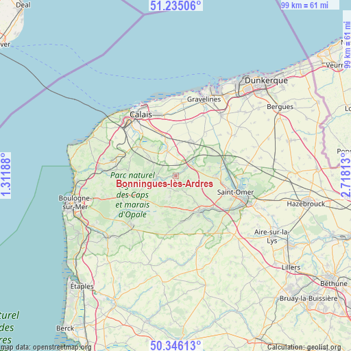
Bonningues-lès-Ardres GPS coordinates[2]
50° 47' 33.756" North, 2° 0' 54.036" East
| Map corner | latitude | longitude |
|---|---|---|
| Upper-left | 51.23506°, | 1.31188° |
| Center: | 50.79271°, | 2.01501° |
| Lower-right: | 50.34613°, | 2.71813° |
| Map W x H: | 98.8×98.8 km | = 61.4×61.4mi |
| max Lat: | 51.07786° ⇑0.7% North |
| Bonningues-lès-Ardres: | 50.79271° |
| min Lat: | ⇓99.3% South 41.3874° |
| min Long | Bonningues-lès | max Long |
| -5.08615° | 2.01501° | 9.52242° |
| W 43%⇐ | ⇒57% E |
Elevation
Elevation of Bonningues-lès-Ardres is 49 m = 161 ft, and this is 144.7 m = 475 ft below average elevation for this country.
| Max E: |
2333 m = 7654 ft | 82.2% |
| Avg. | 193.7 m = 635 ft | |
| Bonningues-lès-Ardres | 49 m = 161 ft | |
Min E: |
-1 m = -3 ft | 17.8% |
See also: France elevation on elevation.city.
Geographical zone
Bonningues-lès-Ardres is located in North temperate zone (between Tropic of Cancer and the Arctic Circle). Distance of this North polar circle is 1753.6 km =1089.6 mi to North.| Distance of | km | miles | from Bonningues-lès-Ardres |
|---|---|---|---|
| North Pole | 4359.4 | 2708.8 | to North |
| Arctic Circle | 1753.6 | 1089.6 | to North |
| Tropic Cancer | 3041.7 | 1890 | to South |
| Equator | 5647.6 | 3509.3 | to South |


Nearby cities:
15 places around Bonningues-lès-Ardres: (largest is in red/bold)
• Acquin-Westbécourt
9 km =5.6 mi,  143°
143°
• Alquines
5.9 km =3.7 mi,  194°
194°
• Ardres
7.6 km =4.7 mi,  342°
342°
• Bayenghem-lès-Éperlecques
7.6 km =4.7 mi,  77°
77°
• Bouquehault
8.7 km =5.4 mi,  294°
294°
• Brêmes
7.4 km =4.6 mi, 338°
• Landrethun-lès-Ardres
5.3 km =3.3 mi,  313°
313°
• Licques
5.5 km =3.4 mi,  259°
259°
• Louches
4.2 km =2.6 mi,  351°
351°
• Mentque-Nortbécourt
5.1 km =3.2 mi,  101°
101°
• Nordausques
5.5 km =3.4 mi,  58°
58°
• Polincove
8.1 km =5 mi,  41°
41°
• Recques-sur-Hem
6.9 km =4.3 mi,  47°
47°
• Tournehem-sur-la-Hem
2.6 km =1.6 mi,  71°
71°
• Zutkerque
7.7 km =4.8 mi,  29°
29°
Sources, notices
• [Note1] Compared only with cities in France existing in our database
• [Src1] Map data: © OpenStreetMap contributors (CC-BY-SA)
• [Src2] Other city data from geonames.org with taken over terms of usage.
• [Src3] Geographical zone / Annual Mean Temperature by Robert A. Rohde @ Wikipedia
