Longes geodata
Longes (Auvergne-Rhône-Alpes) is a populated place; located in France in Europe/Paris (GMT+2) time zone. With population of 806 people, there are 10540 cities with bigger population in this country. Compared to other cities in France, 74.1% of cities are located further ↑North; 73.6% of cities are located further ←West and 90.8% of cities have lower elevation than Longes. Note1
Administrative division(s):
- Level 1: Auvergne-Rhône-Alpes
- Level 2: Département du Rhône
- Level 3: Arrondissement de Lyon
- Level 4: Longes


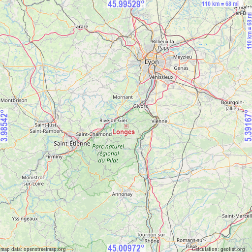
Longes GPS coordinates[2]
45° 30' 16.776" North, 4° 41' 18.78" East
| Map corner | latitude | longitude |
|---|---|---|
| Upper-left | 45.99529°, | 3.98542° |
| Center: | 45.50466°, | 4.68855° |
| Lower-right: | 45.00972°, | 5.39167° |
| Map W x H: | 109.6×109.6 km | = 68.1×68.1mi |
| max Lat: | 51.07786° ⇑74.1% North |
| Longes: | 45.50466° |
| min Lat: | ⇓25.9% South 41.3874° |
| min Long | Longes | max Long |
| -5.08615° | 4.68855° | 9.52242° |
| W 73.6%⇐ | ⇒26.4% E |
Elevation
Elevation of Longes is 445 m = 1460 ft, and this is 251.3 m = 824 ft above average elevation for this country.
| Max E: |
2333 m = 7654 ft | 9.2% |
| Longes | 445 m 1460 ft | |
| Avg. | 193.7 m = 635 ft | |
Min E: |
-1 m = -3 ft | 90.8% |
See also: France elevation on elevation.city.
Geographical zone
Longes is located in North temperate zone (between Tropic of Cancer and the Arctic Circle). Distance of this North polar circle is 2341.5 km =1454.9 mi to North.| Distance of | km | miles | from Longes |
|---|---|---|---|
| North Pole | 4947.4 | 3074.2 | to North |
| Arctic Circle | 2341.5 | 1454.9 | to North |
| Tropic Cancer | 2453.7 | 1524.7 | to South |
| Equator | 5059.6 | 3143.9 | to South |


Nearby cities:
15 places around Longes: (largest is in red/bold)
• Chuyer
5.3 km =3.3 mi,  175°
175°
• Châteauneuf
4.4 km =2.7 mi,  300°
300°
• Condrieu
7.7 km =4.8 mi,  126°
126°
• Farnay
8.3 km =5.2 mi,  263°
263°
• Les Haies
4.6 km =2.9 mi,  90°
90°
• Les Roches-de-Condrieu
8.4 km =5.2 mi, 133°
• Lorette
8.3 km =5.2 mi,  274°
274°
• Rive-de-Gier
6.2 km =3.9 mi,  294°
294°
• Saint-Joseph
7.9 km =4.9 mi,  318°
318°
• Saint-Michel-sur-Rhône
8.2 km =5.1 mi,  150°
150°
• Saint-Romain-en-Gier
6.9 km =4.3 mi,  11°
11°
• Tartaras
5.3 km =3.3 mi,  341°
341°
• Trèves
4 km =2.5 mi,  345°
345°
• Vérin
7.6 km =4.7 mi,  138°
138°
• Échalas
5.7 km =3.5 mi,  21°
21°
Sources, notices
• [Note1] Compared only with cities in France existing in our database
• [Src1] Map data: © OpenStreetMap contributors (CC-BY-SA)
• [Src2] Other city data from geonames.org with taken over terms of usage.
• [Src3] Geographical zone / Annual Mean Temperature by Robert A. Rohde @ Wikipedia
