Saint-Joseph geodata
Saint-Joseph (Auvergne-Rhône-Alpes) is a populated place; located in France in Europe/Paris (GMT+2) time zone. With population of 1,772 people, there are 5351 cities with bigger population in this country. Compared to other cities in France, 73.3% of cities are located further ↑North; 73% of cities are located further ←West and 83.4% of cities have lower elevation than Saint-Joseph. Note1
Administrative division(s):
- Level 1: Auvergne-Rhône-Alpes
- Level 2: Département de la Loire
- Level 3: Arrondissement de Saint-Étienne
- Level 4: Saint-Joseph


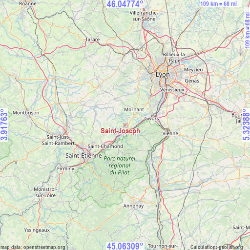
Saint-Joseph GPS coordinates[2]
45° 33' 27.252" North, 4° 37' 14.736" East
| Map corner | latitude | longitude |
|---|---|---|
| Upper-left | 46.04774°, | 3.91763° |
| Center: | 45.55757°, | 4.62076° |
| Lower-right: | 45.06309°, | 5.32388° |
| Map W x H: | 109.5×109.5 km | = 68×68mi |
| max Lat: | 51.07786° ⇑73.3% North |
| Saint-Joseph: | 45.55757° |
| min Lat: | ⇓26.7% South 41.3874° |
| min Long | Saint-Joseph | max Long |
| -5.08615° | 4.62076° | 9.52242° |
| W 73%⇐ | ⇒27% E |
Elevation
Elevation of Saint-Joseph is 327 m = 1073 ft, and this is 133.3 m = 437 ft above average elevation for this country.
| Max E: |
2333 m = 7654 ft | 16.6% |
| Saint-Joseph | 327 m 1073 ft | |
| Avg. | 193.7 m = 635 ft | |
Min E: |
-1 m = -3 ft | 83.4% |
See also: France elevation on elevation.city.
Geographical zone
Saint-Joseph is located in North temperate zone (between Tropic of Cancer and the Arctic Circle). Distance of this North polar circle is 2335.6 km =1451.3 mi to North.| Distance of | km | miles | from Saint-Joseph |
|---|---|---|---|
| North Pole | 4941.5 | 3070.5 | to North |
| Arctic Circle | 2335.6 | 1451.3 | to North |
| Tropic Cancer | 2459.6 | 1528.3 | to South |
| Equator | 5065.5 | 3147.6 | to South |


Nearby cities:
15 places around Saint-Joseph: (largest is in red/bold)
• Châteauneuf
4 km =2.5 mi,  157°
157°
• Lorette
6 km =3.7 mi,  209°
209°
• Rive-de-Gier
3.4 km =2.1 mi,  186°
186°
• Saint-Andéol-le-Château
6.6 km =4.1 mi,  61°
61°
• Saint-Didier-sous-Riverie
4.4 km =2.7 mi,  345°
345°
• Saint-Jean-de-Touslas
3.7 km =2.3 mi,  54°
54°
• Saint-Martin-la-Plaine
2.2 km =1.4 mi,  235°
235°
• Saint-Maurice-sur-Dargoire
2.9 km =1.8 mi,  16°
16°
• Saint-Romain-en-Gier
6.8 km =4.2 mi,  82°
82°
• Saint-Romain-en-Jarez
6.6 km =4.1 mi,  271°
271°
• Saint-Sorlin
7.1 km =4.4 mi,  11°
11°
• Sainte-Catherine
6.1 km =3.8 mi,  319°
319°
• Tartaras
3.7 km =2.3 mi,  104°
104°
• Trèves
4.8 km =3 mi,  115°
115°
• Échalas
7.4 km =4.6 mi,  94°
94°
Sources, notices
• [Note1] Compared only with cities in France existing in our database
• [Src1] Map data: © OpenStreetMap contributors (CC-BY-SA)
• [Src2] Other city data from geonames.org with taken over terms of usage.
• [Src3] Geographical zone / Annual Mean Temperature by Robert A. Rohde @ Wikipedia
