Livry-sur-Seine geodata
Livry-sur-Seine (Île-de-France) is a populated place; located in France in Europe/Paris (GMT+2) time zone. With population of 2,074 people, there are 4633 cities with bigger population in this country. Compared to other cities in France, 68.8% of cities are located further ↓South; 53.1% of cities are located further ←West and 73.6% of cities have higher elevation than Livry-sur-Seine. Note1
Administrative division(s):
- Level 1: Île-de-France
- Level 2: Seine-et-Marne
- Level 3: Arrondissement de Melun
- Level 4: Livry-sur-Seine


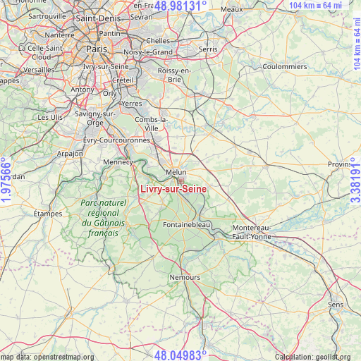
Livry-sur-Seine GPS coordinates[2]
48° 31' 3.756" North, 2° 40' 43.644" East
| Map corner | latitude | longitude |
|---|---|---|
| Upper-left | 48.98131°, | 1.97566° |
| Center: | 48.51771°, | 2.67879° |
| Lower-right: | 48.04983°, | 3.38191° |
| Map W x H: | 103.6×103.6 km | = 64.4×64.4mi |
| max Lat: | 51.07786° ⇑31.2% North |
| Livry-sur-Seine: | 48.51771° |
| min Lat: | ⇓68.8% South 41.3874° |
| min Long | Livry-sur-Seine | max Long |
| -5.08615° | 2.67879° | 9.52242° |
| W 53.1%⇐ | ⇒46.9% E |
Elevation
Elevation of Livry-sur-Seine is 70 m = 230 ft, and this is 123.7 m = 406 ft below average elevation for this country.
| Max E: |
2333 m = 7654 ft | 73.6% |
| Avg. | 193.7 m = 635 ft | |
| Livry-sur-Seine | 70 m = 230 ft | |
Min E: |
-1 m = -3 ft | 26.4% |
See also: France elevation on elevation.city.
Geographical zone
Livry-sur-Seine is located in North temperate zone (between Tropic of Cancer and the Arctic Circle). Distance of this North polar circle is 2006.5 km =1246.8 mi to North.| Distance of | km | miles | from Livry-sur-Seine |
|---|---|---|---|
| North Pole | 4612.4 | 2866 | to North |
| Arctic Circle | 2006.5 | 1246.8 | to North |
| Tropic Cancer | 2788.7 | 1732.8 | to South |
| Equator | 5394.7 | 3352.1 | to South |


Nearby cities:
15 places around Livry-sur-Seine: (largest is in red/bold)
• Bois-le-Roi
5.3 km =3.3 mi,  158°
158°
• Boissise-la-Bertrand
6.7 km =4.2 mi,  280°
280°
• Cesson
7.2 km =4.5 mi,  313°
313°
• Chartrettes
3.7 km =2.3 mi,  153°
153°
• Dammarie-les-Lys
2.1 km =1.3 mi,  266°
266°
• La Rochette
1.5 km =0.9 mi,  228°
228°
• Le Mée-sur-Seine
4 km =2.5 mi,  292°
292°
• Maincy
3.9 km =2.4 mi,  23°
23°
• Melun
3.6 km =2.2 mi,  329°
329°
• Moisenay
6.5 km =4 mi,  39°
39°
• Rubelles
4 km =2.5 mi,  356°
356°
• Sivry-Courtry
5.7 km =3.5 mi,  78°
78°
• Vaux-le-Pénil
1.5 km =0.9 mi, 39°
• Vert-Saint-Denis
7.1 km =4.4 mi,  322°
322°
• Voisenon
6.1 km =3.8 mi,  350°
350°
Sources, notices
• [Note1] Compared only with cities in France existing in our database
• [Src1] Map data: © OpenStreetMap contributors (CC-BY-SA)
• [Src2] Other city data from geonames.org with taken over terms of usage.
• [Src3] Geographical zone / Annual Mean Temperature by Robert A. Rohde @ Wikipedia
