Bois-le-Roi geodata
Bois-le-Roi (Île-de-France) is a populated place; located in France in Europe/Paris (GMT+2) time zone. With population of 5,903 people, there are 1672 cities with bigger population in this country. Compared to other cities in France, 67.7% of cities are located further ↓South; 53.6% of cities are located further ←West and 77.8% of cities have higher elevation than Bois-le-Roi. Note1
Administrative division(s):
- Level 1: Île-de-France
- Level 2: Seine-et-Marne
- Level 3: Arrondissement de Fontainebleau
- Level 4: Bois-le-Roi


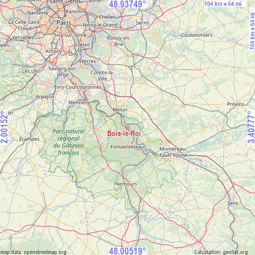
Bois-le-Roi GPS coordinates[2]
48° 28' 24.528" North, 2° 42' 16.704" East
| Map corner | latitude | longitude |
|---|---|---|
| Upper-left | 48.93749°, | 2.00152° |
| Center: | 48.47348°, | 2.70464° |
| Lower-right: | 48.00519°, | 3.40777° |
| Map W x H: | 103.7×103.7 km | = 64.4×64.4mi |
| max Lat: | 51.07786° ⇑32.3% North |
| Bois-le-Roi: | 48.47348° |
| min Lat: | ⇓67.7% South 41.3874° |
| min Long | Bois-le-Roi | max Long |
| -5.08615° | 2.70464° | 9.52242° |
| W 53.6%⇐ | ⇒46.4% E |
Elevation
Elevation of Bois-le-Roi is 60 m = 197 ft, and this is 133.7 m = 439 ft below average elevation for this country.
| Max E: |
2333 m = 7654 ft | 77.8% |
| Avg. | 193.7 m = 635 ft | |
| Bois-le-Roi | 60 m = 197 ft | |
Min E: |
-1 m = -3 ft | 22.2% |
See also: France elevation on elevation.city.
Geographical zone
Bois-le-Roi is located in North temperate zone (between Tropic of Cancer and the Arctic Circle). Distance of this North polar circle is 2011.4 km =1249.8 mi to North.| Distance of | km | miles | from Bois-le-Roi |
|---|---|---|---|
| North Pole | 4617.3 | 2869.1 | to North |
| Arctic Circle | 2011.4 | 1249.8 | to North |
| Tropic Cancer | 2783.8 | 1729.8 | to South |
| Equator | 5389.7 | 3349 | to South |


Nearby cities:
15 places around Bois-le-Roi: (largest is in red/bold)
• Chailly-en-Bière
7.2 km =4.5 mi,  264°
264°
• Chartrettes
1.6 km =1 mi,  350°
350°
• Dammarie-les-Lys
6.3 km =3.9 mi,  320°
320°
• Fontaine-le-Port
4.7 km =2.9 mi,  73°
73°
• Fontainebleau
7.2 km =4.5 mi,  181°
181°
• Féricy
7.2 km =4.5 mi,  101°
101°
• Héricy
5.2 km =3.2 mi,  122°
122°
• La Rochette
5 km =3.1 mi, 322°
• Le Châtelet-en-Brie
7.4 km =4.6 mi,  59°
59°
• Livry-sur-Seine
5.3 km =3.3 mi,  338°
338°
• Samois-sur-Seine
4.1 km =2.5 mi, 124°
• Samoreau
6.2 km =3.9 mi,  142°
142°
• Sivry-Courtry
7.1 km =4.4 mi,  31°
31°
• Vaux-le-Pénil
6.1 km =3.8 mi, 351°
• Vulaines-sur-Seine
6.4 km =4 mi, 136°
Sources, notices
• [Note1] Compared only with cities in France existing in our database
• [Src1] Map data: © OpenStreetMap contributors (CC-BY-SA)
• [Src2] Other city data from geonames.org with taken over terms of usage.
• [Src3] Geographical zone / Annual Mean Temperature by Robert A. Rohde @ Wikipedia
