Lay-Saint-Christophe geodata
Lay-Saint-Christophe (Grand Est) is a populated place; located in France in Europe/Paris (GMT+2) time zone. With population of 2,681 people, there are 3638 cities with bigger population in this country. Compared to other cities in France, 74.3% of cities are located further ↓South; 89.3% of cities are located further ←West and 66.6% of cities have lower elevation than Lay-Saint-Christophe. Note1
Administrative division(s):
- Level 1: Grand Est
- Level 2: Meurthe-et-Moselle
- Level 3: Arrondissement de Nancy
- Level 4: Lay-Saint-Christophe


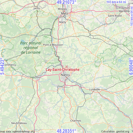
Lay-Saint-Christophe GPS coordinates[2]
48° 44' 57.336" North, 6° 11' 50.46" East
| Map corner | latitude | longitude |
|---|---|---|
| Upper-left | 49.21073°, | 5.49423° |
| Center: | 48.74926°, | 6.19735° |
| Lower-right: | 48.28351°, | 6.90048° |
| Map W x H: | 103.1×103.1 km | = 64.1×64.1mi |
| max Lat: | 51.07786° ⇑25.7% North |
| Lay-Saint-Christophe: | 48.74926° |
| min Lat: | ⇓74.3% South 41.3874° |
| min Long | Lay-Saint-Chris | max Long |
| -5.08615° | 6.19735° | 9.52242° |
| W 89.3%⇐ | ⇒10.7% E |
Elevation
Elevation of Lay-Saint-Christophe is 202 m = 663 ft, and this is 8.3 m = 27 ft above average elevation for this country.
| Max E: |
2333 m = 7654 ft | 33.4% |
| Lay-Saint-Christophe | 202 m 663 ft | |
| Avg. | 193.7 m = 635 ft | |
Min E: |
-1 m = -3 ft | 66.6% |
See also: France elevation on elevation.city.
Geographical zone
Lay-Saint-Christophe is located in North temperate zone (between Tropic of Cancer and the Arctic Circle). Distance of this North polar circle is 1980.8 km =1230.8 mi to North.| Distance of | km | miles | from Lay-Saint-Christophe |
|---|---|---|---|
| North Pole | 4586.7 | 2850 | to North |
| Arctic Circle | 1980.8 | 1230.8 | to North |
| Tropic Cancer | 2814.5 | 1748.8 | to South |
| Equator | 5420.4 | 3368.1 | to South |


Nearby cities:
15 places around Lay-Saint-Christophe: (largest is in red/bold)
• Bouxières-aux-Chênes
5.3 km =3.3 mi,  61°
61°
• Bouxières-aux-Dames
2.6 km =1.6 mi,  282°
282°
• Champigneulles
3.1 km =1.9 mi,  237°
237°
• Custines
6.1 km =3.8 mi,  320°
320°
• Dommartemont
4.2 km =2.6 mi,  162°
162°
• Essey-lès-Nancy
5.4 km =3.4 mi, 156°
• Eulmont
2.2 km =1.4 mi,  87°
87°
• Faulx
4.8 km =3 mi,  358°
358°
• Frouard
5.1 km =3.2 mi, 283°
• Malleloy
5.7 km =3.5 mi,  333°
333°
• Malzéville
4.2 km =2.6 mi,  192°
192°
• Maxéville
4.6 km =2.9 mi,  209°
209°
• Pompey
5.6 km =3.5 mi,  292°
292°
• Saint-Max
5.1 km =3.2 mi,  172°
172°
• Seichamps
6.1 km =3.8 mi,  129°
129°
Sources, notices
• [Note1] Compared only with cities in France existing in our database
• [Src1] Map data: © OpenStreetMap contributors (CC-BY-SA)
• [Src2] Other city data from geonames.org with taken over terms of usage.
• [Src3] Geographical zone / Annual Mean Temperature by Robert A. Rohde @ Wikipedia
