Malleloy geodata
Malleloy (Grand Est) is a populated place; located in France in Europe/Paris (GMT+2) time zone. With population of 924 people, there are 9438 cities with bigger population in this country. Compared to other cities in France, 75.4% of cities are located further ↓South; 89% of cities are located further ←West and 76.5% of cities have lower elevation than Malleloy. Note1
Administrative division(s):
- Level 1: Grand Est
- Level 2: Meurthe-et-Moselle
- Level 3: Arrondissement de Nancy
- Level 4: Malleloy


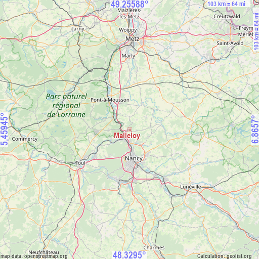
Malleloy GPS coordinates[2]
48° 47' 41.388" North, 6° 9' 45.288" East
| Map corner | latitude | longitude |
|---|---|---|
| Upper-left | 49.25588°, | 5.45945° |
| Center: | 48.79483°, | 6.16258° |
| Lower-right: | 48.3295°, | 6.8657° |
| Map W x H: | 103×103 km | = 64×64mi |
| max Lat: | 51.07786° ⇑24.6% North |
| Malleloy: | 48.79483° |
| min Lat: | ⇓75.4% South 41.3874° |
| min Long | Malleloy | max Long |
| -5.08615° | 6.16258° | 9.52242° |
| W 89%⇐ | ⇒11% E |
Elevation
Elevation of Malleloy is 260 m = 853 ft, and this is 66.3 m = 218 ft above average elevation for this country.
| Max E: |
2333 m = 7654 ft | 23.5% |
| Malleloy | 260 m 853 ft | |
| Avg. | 193.7 m = 635 ft | |
Min E: |
-1 m = -3 ft | 76.5% |
See also: France elevation on elevation.city.
Geographical zone
Malleloy is located in North temperate zone (between Tropic of Cancer and the Arctic Circle). Distance of this North polar circle is 1975.7 km =1227.6 mi to North.| Distance of | km | miles | from Malleloy |
|---|---|---|---|
| North Pole | 4581.6 | 2846.9 | to North |
| Arctic Circle | 1975.7 | 1227.6 | to North |
| Tropic Cancer | 2819.6 | 1752 | to South |
| Equator | 5425.5 | 3371.2 | to South |


Nearby cities:
15 places around Malleloy: (largest is in red/bold)
• Belleau
4.2 km =2.6 mi,  21°
21°
• Belleville
5.1 km =3.2 mi,  300°
300°
• Bouxières-aux-Chênes
7.7 km =4.8 mi,  109°
109°
• Bouxières-aux-Dames
4.5 km =2.8 mi,  179°
179°
• Champigneulles
6.8 km =4.2 mi, 180°
• Custines
1.4 km =0.9 mi,  253°
253°
• Eulmont
6.9 km =4.3 mi,  136°
136°
• Faulx
2.4 km =1.5 mi,  95°
95°
• Frouard
4.5 km =2.8 mi,  211°
211°
• Jeandelaincourt
8.1 km =5 mi,  48°
48°
• Lay-Saint-Christophe
5.7 km =3.5 mi,  153°
153°
• Leyr
7.6 km =4.7 mi,  81°
81°
• Marbache
4.2 km =2.6 mi,  275°
275°
• Pompey
3.9 km =2.4 mi,  222°
222°
• Saizerais
8.6 km =5.3 mi,  268°
268°
Sources, notices
• [Note1] Compared only with cities in France existing in our database
• [Src1] Map data: © OpenStreetMap contributors (CC-BY-SA)
• [Src2] Other city data from geonames.org with taken over terms of usage.
• [Src3] Geographical zone / Annual Mean Temperature by Robert A. Rohde @ Wikipedia
