Lavausseau geodata
Lavausseau (Nouvelle-Aquitaine) is a populated place; located in France in Europe/Paris (GMT+2) time zone. With population of 745 people, there are 11223 cities with bigger population in this country. Compared to other cities in France, 59.6% of cities are located further ↑North; 77.5% of cities are located further →East and 51.4% of cities have lower elevation than Lavausseau. Note1
Administrative division(s):
- Level 1: Nouvelle-Aquitaine
- Level 2: Vienne
- Level 3: Arrondissement de Poitiers
- Level 4: Boivre-la-Vallée


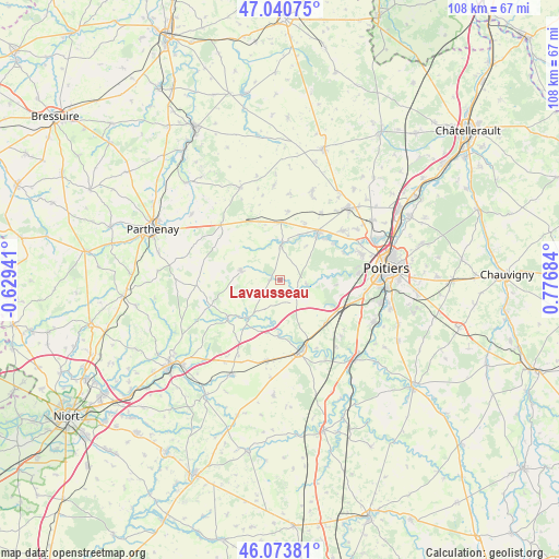
Lavausseau GPS coordinates[2]
46° 33' 33.948" North, 0° 4' 25.356" East
| Map corner | latitude | longitude |
|---|---|---|
| Upper-left | 47.04075°, | -0.62941° |
| Center: | 46.55943°, | 0.07371° |
| Lower-right: | 46.07381°, | 0.77684° |
| Map W x H: | 107.5×107.5 km | = 66.8×66.8mi |
| max Lat: | 51.07786° ⇑59.6% North |
| Lavausseau: | 46.55943° |
| min Lat: | ⇓40.4% South 41.3874° |
| min Long | Lavausseau | max Long |
| -5.08615° | 0.07371° | 9.52242° |
| W 22.5%⇐ | ⇒77.5% E |
Elevation
Elevation of Lavausseau is 137 m = 449 ft, and this is 56.7 m = 186 ft below average elevation for this country.
| Max E: |
2333 m = 7654 ft | 48.6% |
| Avg. | 193.7 m = 635 ft | |
| Lavausseau | 137 m = 449 ft | |
Min E: |
-1 m = -3 ft | 51.4% |
See also: France elevation on elevation.city.
Geographical zone
Lavausseau is located in North temperate zone (between Tropic of Cancer and the Arctic Circle). Distance of this North polar circle is 2224.3 km =1382.1 mi to North.| Distance of | km | miles | from Lavausseau |
|---|---|---|---|
| North Pole | 4830.1 | 3001.3 | to North |
| Arctic Circle | 2224.3 | 1382.1 | to North |
| Tropic Cancer | 2571 | 1597.5 | to South |
| Equator | 5176.9 | 3216.8 | to South |


Nearby cities:
15 places around Lavausseau: (largest is in red/bold)
• Ayron
11.2 km =7 mi,  0°
0°
• Benassay
2 km =1.2 mi,  268°
268°
• Béruges
10.3 km =6.4 mi,  85°
85°
• Chalandray
12.7 km =7.9 mi,  332°
332°
• Chiré-en-Montreuil
9.7 km =6 mi,  24°
24°
• Coulombiers
11.9 km =7.4 mi,  133°
133°
• Jazeneuil
10.5 km =6.5 mi,  182°
182°
• La Chapelle-Montreuil
4.4 km =2.7 mi, 131°
• Latillé
6.7 km =4.2 mi, 0°
• Lusignan
14.3 km =8.9 mi,  164°
164°
• Montreuil-Bonnin
5.3 km =3.3 mi,  99°
99°
• Ménigoute
12.3 km =7.6 mi,  235°
235°
• Sanxay
9.6 km =6 mi,  220°
220°
• Vasles
7.8 km =4.8 mi,  283°
283°
• Vouillé
11.6 km =7.2 mi,  38°
38°
Sources, notices
• [Note1] Compared only with cities in France existing in our database
• [Src1] Map data: © OpenStreetMap contributors (CC-BY-SA)
• [Src2] Other city data from geonames.org with taken over terms of usage.
• [Src3] Geographical zone / Annual Mean Temperature by Robert A. Rohde @ Wikipedia
