Saint-Caprais-de-Bordeaux geodata
Saint-Caprais-de-Bordeaux (Nouvelle-Aquitaine) is a populated place; located in France in Europe/Paris (GMT+2) time zone. With population of 2,743 people, there are 3571 cities with bigger population in this country. Compared to other cities in France, 81.7% of cities are located further ↑North; 82.6% of cities are located further →East and 67.8% of cities have higher elevation than Saint-Caprais-de-Bordeaux. Note1
Administrative division(s):
- Level 1: Nouvelle-Aquitaine
- Level 2: Gironde
- Level 3: Arrondissement de Bordeaux
- Level 4: Saint-Caprais-de-Bordeaux
Current local time in Saint-Caprais-de-Bordeaux:
05:58 AM, WednesdayDifference from your time zone: hours


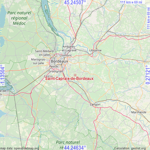
Saint-Caprais-de-Bordeaux GPS coordinates[2]
44° 44' 52.296" North, 0° 25' 54.912" West
| Map corner | latitude | longitude |
|---|---|---|
| Upper-left | 45.24507°, | -1.13504° |
| Center: | 44.74786°, | -0.43192° |
| Lower-right: | 44.24634°, | 0.27121° |
| Map W x H: | 111×111 km | = 69×69mi |
| max Lat: | 51.07786° ⇑81.7% North |
| Saint-Caprais-de-Bordeaux: | 44.74786° |
| min Lat: | ⇓18.3% South 41.3874° |
| min Long | Saint-Caprais-d | max Long |
| -5.08615° | -0.43192° | 9.52242° |
| W 17.4%⇐ | ⇒82.6% E |
Elevation
Elevation of Saint-Caprais-de-Bordeaux is 83 m = 272 ft, and this is 110.7 m = 363 ft below average elevation for this country.
| Max E: |
2333 m = 7654 ft | 67.8% |
| Avg. | 193.7 m = 635 ft | |
| Saint-Caprais-de-Bordeaux | 83 m = 272 ft | |
Min E: |
-1 m = -3 ft | 32.2% |
See also: France elevation on elevation.city.
Geographical zone
Saint-Caprais-de-Bordeaux is located in North temperate zone (between Tropic of Cancer and the Arctic Circle). Distance of this Northern Tropic circle is 2369.6 km =1472.4 mi to South.| Distance of | km | miles | from Saint-Caprais-de-Bordeaux |
|---|---|---|---|
| North Pole | 5031.6 | 3126.5 | to North |
| Arctic Circle | 2425.7 | 1507.3 | to North |
| Tropic Cancer | 2369.6 | 1472.4 | to South |
| Equator | 4975.5 | 3091.6 | to South |


Nearby cities:
15 places around Saint-Caprais-de-Bordeaux: (largest is in red/bold)
• Ayguemorte-les-Graves
5.7 km =3.5 mi,  222°
222°
• Baurech
2.5 km =1.6 mi,  192°
192°
• Beautiran
5.1 km =3.2 mi,  198°
198°
• Cambes
3 km =1.9 mi,  233°
233°
• Camblanes-et-Meynac
4.7 km =2.9 mi,  294°
294°
• Cénac
4.2 km =2.6 mi,  328°
328°
• Haux
5.1 km =3.2 mi,  105°
105°
• Isle-Saint-Georges
4.1 km =2.5 mi, 231°
• Langoiran
5.3 km =3.3 mi,  145°
145°
• Le Tourne
4.6 km =2.9 mi, 152°
• Lignan-de-Bordeaux
5.4 km =3.4 mi,  3°
3°
• Portets
5.7 km =3.5 mi,  174°
174°
• Quinsac
4.4 km =2.7 mi,  280°
280°
• Sadirac
4 km =2.5 mi,  21°
21°
• Tabanac
3.7 km =2.3 mi, 145°
Sources, notices
• [Note1] Compared only with cities in France existing in our database
• [Src1] Map data: © OpenStreetMap contributors (CC-BY-SA)
• [Src2] Other city data from geonames.org with taken over terms of usage.
• [Src3] Geographical zone / Annual Mean Temperature by Robert A. Rohde @ Wikipedia
