Lalouvesc geodata
Lalouvesc (Auvergne-Rhône-Alpes) is a populated place; located in France in Europe/Paris (GMT+2) time zone. With population of 519 people, there are 14840 cities with bigger population in this country. Compared to other cities in France, 78.3% of cities are located further ↑North; 72.3% of cities are located further ←West and 99.4% of cities have lower elevation than Lalouvesc. Note1
Administrative division(s):
- Level 1: Auvergne-Rhône-Alpes
- Level 2: Département de l'Ardèche
- Level 3: Arrondissement de Tournon-sur-Rhône
- Level 4: Lalouvesc


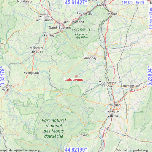
Lalouvesc GPS coordinates[2]
45° 7' 13.044" North, 4° 32' 5.676" East
| Map corner | latitude | longitude |
|---|---|---|
| Upper-left | 45.61427°, | 3.83179° |
| Center: | 45.12029°, | 4.53491° |
| Lower-right: | 44.62199°, | 5.23804° |
| Map W x H: | 110.3×110.3 km | = 68.5×68.5mi |
| max Lat: | 51.07786° ⇑78.3% North |
| Lalouvesc: | 45.12029° |
| min Lat: | ⇓21.7% South 41.3874° |
| min Long | Lalouvesc | max Long |
| -5.08615° | 4.53491° | 9.52242° |
| W 72.3%⇐ | ⇒27.7% E |
Elevation
Elevation of Lalouvesc is 1086 m = 3563 ft, and this is 892.3 m = 2927 ft above average elevation for this country.
| Max E: |
2333 m = 7654 ft | 0.59999999999999% |
| Lalouvesc | 1086 m 3563 ft | |
| Avg. | 193.7 m = 635 ft | |
Min E: |
-1 m = -3 ft | 99.4% |
See also: France elevation on elevation.city.
Geographical zone
Lalouvesc is located in North temperate zone (between Tropic of Cancer and the Arctic Circle). Distance of this North polar circle is 2384.3 km =1481.5 mi to North.| Distance of | km | miles | from Lalouvesc |
|---|---|---|---|
| North Pole | 4990.2 | 3100.8 | to North |
| Arctic Circle | 2384.3 | 1481.5 | to North |
| Tropic Cancer | 2411 | 1498.1 | to South |
| Equator | 5016.9 | 3117.4 | to South |


Nearby cities:
15 places around Lalouvesc: (largest is in red/bold)
• Colombier-le-Vieux
14.1 km =8.8 mi,  115°
115°
• Désaignes
14 km =8.7 mi,  185°
185°
• Empurany
12.1 km =7.5 mi,  151°
151°
• Lamastre
15.3 km =9.5 mi,  166°
166°
• Le Crestet
15.1 km =9.4 mi,  141°
141°
• Montregard
15.4 km =9.6 mi,  286°
286°
• Quintenas
14.2 km =8.8 mi,  57°
57°
• Roiffieux
15.1 km =9.4 mi,  38°
38°
• Saint-Félicien
8.2 km =5.1 mi, 117°
• Saint-Victor
11 km =6.8 mi,  101°
101°
• Satillieu
7.1 km =4.4 mi, 61°
• Vanosc
11.6 km =7.2 mi,  6°
6°
• Villevocance
12.4 km =7.7 mi,  19°
19°
• Vocance
9.1 km =5.7 mi, 8°
• Étables
15.1 km =9.4 mi, 98°
Sources, notices
• [Note1] Compared only with cities in France existing in our database
• [Src1] Map data: © OpenStreetMap contributors (CC-BY-SA)
• [Src2] Other city data from geonames.org with taken over terms of usage.
• [Src3] Geographical zone / Annual Mean Temperature by Robert A. Rohde @ Wikipedia
