Lagnieu geodata
Lagnieu (Auvergne-Rhône-Alpes) is a populated place; located in France in Europe/Paris (GMT+2) time zone. With population of 6,454 people, there are 1533 cities with bigger population in this country. Compared to other cities in France, 67.6% of cities are located further ↑North; 81% of cities are located further ←West and 72.8% of cities have lower elevation than Lagnieu. Note1
Administrative division(s):
- Level 1: Auvergne-Rhône-Alpes
- Level 2: Département de l'Ain
- Level 3: Arrondissement de Belley
- Level 4: Lagnieu


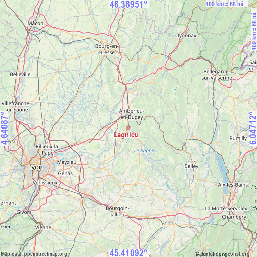
Lagnieu GPS coordinates[2]
45° 54' 8.532" North, 5° 20' 38.364" East
| Map corner | latitude | longitude |
|---|---|---|
| Upper-left | 46.38951°, | 4.64087° |
| Center: | 45.90237°, | 5.34399° |
| Lower-right: | 45.41092°, | 6.04712° |
| Map W x H: | 108.8×108.8 km | = 67.6×67.6mi |
| max Lat: | 51.07786° ⇑67.6% North |
| Lagnieu: | 45.90237° |
| min Lat: | ⇓32.4% South 41.3874° |
| min Long | Lagnieu | max Long |
| -5.08615° | 5.34399° | 9.52242° |
| W 81%⇐ | ⇒19% E |
Elevation
Elevation of Lagnieu is 235 m = 771 ft, and this is 41.3 m = 135 ft above average elevation for this country.
| Max E: |
2333 m = 7654 ft | 27.2% |
| Lagnieu | 235 m 771 ft | |
| Avg. | 193.7 m = 635 ft | |
Min E: |
-1 m = -3 ft | 72.8% |
See also: France elevation on elevation.city.
Geographical zone
Lagnieu is located in North temperate zone (between Tropic of Cancer and the Arctic Circle). Distance of this North polar circle is 2297.3 km =1427.5 mi to North.| Distance of | km | miles | from Lagnieu |
|---|---|---|---|
| North Pole | 4903.2 | 3046.7 | to North |
| Arctic Circle | 2297.3 | 1427.5 | to North |
| Tropic Cancer | 2497.9 | 1552.1 | to South |
| Equator | 5103.9 | 3171.4 | to South |


Nearby cities:
15 places around Lagnieu: (largest is in red/bold)
• Ambutrix
4 km =2.5 mi,  354°
354°
• Ambérieu-en-Bugey
6.4 km =4 mi,  5°
5°
• Bettant
4.8 km =3 mi, 14°
• Chazey-sur-Ain
7.1 km =4.4 mi,  261°
261°
• La Balme-les-Grottes
5.7 km =3.5 mi,  188°
188°
• Leyment
4.7 km =2.9 mi,  300°
300°
• Parmilieu
7 km =4.3 mi,  172°
172°
• Saint-Denis-en-Bugey
5.4 km =3.4 mi, 346°
• Saint-Maurice-de-Rémens
8.2 km =5.1 mi,  318°
318°
• Saint-Sorlin-en-Bugey
2.6 km =1.6 mi,  136°
136°
• Sainte-Julie
5.2 km =3.2 mi,  254°
254°
• Sault-Brénaz
6.3 km =3.9 mi, 136°
• Torcieu
4.5 km =2.8 mi,  58°
58°
• Vaux-en-Bugey
2.8 km =1.7 mi, 11°
• Vertrieu
3.3 km =2.1 mi,  155°
155°
Sources, notices
• [Note1] Compared only with cities in France existing in our database
• [Src1] Map data: © OpenStreetMap contributors (CC-BY-SA)
• [Src2] Other city data from geonames.org with taken over terms of usage.
• [Src3] Geographical zone / Annual Mean Temperature by Robert A. Rohde @ Wikipedia
