La Geneytouse geodata
La Geneytouse (Nouvelle-Aquitaine) is a populated place; located in France in Europe/Paris (GMT+2) time zone. With population of 758 people, there are 11078 cities with bigger population in this country. Compared to other cities in France, 69.5% of cities are located further ↑North; 63.4% of cities are located further →East and 89.3% of cities have lower elevation than La Geneytouse. Note1
Administrative division(s):
- Level 1: Nouvelle-Aquitaine
- Level 2: Haute-Vienne
- Level 3: Arrondissement de Limoges
- Level 4: La Geneytouse


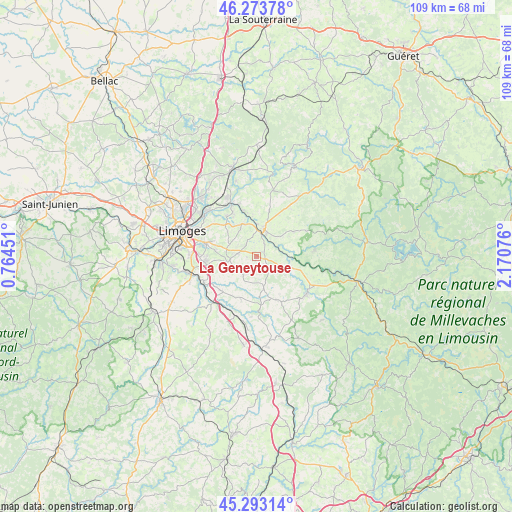
La Geneytouse GPS coordinates[2]
45° 47' 8.232" North, 1° 28' 3.504" East
| Map corner | latitude | longitude |
|---|---|---|
| Upper-left | 46.27378°, | 0.76451° |
| Center: | 45.78562°, | 1.46764° |
| Lower-right: | 45.29314°, | 2.17076° |
| Map W x H: | 109×109 km | = 67.7×67.7mi |
| max Lat: | 51.07786° ⇑69.5% North |
| La Geneytouse: | 45.78562° |
| min Lat: | ⇓30.5% South 41.3874° |
| min Long | La Geneytouse | max Long |
| -5.08615° | 1.46764° | 9.52242° |
| W 36.6%⇐ | ⇒63.4% E |
Elevation
Elevation of La Geneytouse is 413 m = 1355 ft, and this is 219.3 m = 719 ft above average elevation for this country.
| Max E: |
2333 m = 7654 ft | 10.7% |
| La Geneytouse | 413 m 1355 ft | |
| Avg. | 193.7 m = 635 ft | |
Min E: |
-1 m = -3 ft | 89.3% |
See also: France elevation on elevation.city.
Geographical zone
La Geneytouse is located in North temperate zone (between Tropic of Cancer and the Arctic Circle). Distance of this North polar circle is 2310.3 km =1435.6 mi to North.| Distance of | km | miles | from La Geneytouse |
|---|---|---|---|
| North Pole | 4916.2 | 3054.8 | to North |
| Arctic Circle | 2310.3 | 1435.6 | to North |
| Tropic Cancer | 2485 | 1544.1 | to South |
| Equator | 5090.9 | 3163.3 | to South |


Nearby cities:
15 places around La Geneytouse: (largest is in red/bold)
• Aureil
6.3 km =3.9 mi,  290°
290°
• Boisseuil
10.7 km =6.6 mi,  260°
260°
• Bujaleuf
12.5 km =7.8 mi,  84°
84°
• Champnétery
9.6 km =6 mi,  57°
57°
• Eyjeaux
5.9 km =3.7 mi, 260°
• Feytiat
10.9 km =6.8 mi,  284°
284°
• Linards
10.6 km =6.6 mi,  152°
152°
• Neuvic-Entier
13.2 km =8.2 mi,  121°
121°
• Royères
8.2 km =5.1 mi,  343°
343°
• Saint-Bonnet-Briance
8.7 km =5.4 mi,  175°
175°
• Saint-Hilaire-Bonneval
10.3 km =6.4 mi,  224°
224°
• Saint-Just-le-Martel
10.6 km =6.6 mi,  323°
323°
• Saint-Léonard-de-Noblat
6 km =3.7 mi,  17°
17°
• Saint-Paul
4.8 km =3 mi, 215°
• Saint-Priest-Taurion
12.4 km =7.7 mi,  334°
334°
Sources, notices
• [Note1] Compared only with cities in France existing in our database
• [Src1] Map data: © OpenStreetMap contributors (CC-BY-SA)
• [Src2] Other city data from geonames.org with taken over terms of usage.
• [Src3] Geographical zone / Annual Mean Temperature by Robert A. Rohde @ Wikipedia
