La Faute-sur-Mer geodata
La Faute-sur-Mer (Pays de la Loire) is a populated place; located in France in Europe/Paris (GMT+2) time zone. With population of 972 people, there are 9049 cities with bigger population in this country. Compared to other cities in France, 61.9% of cities are located further ↑North; 91% of cities are located further →East and 99.9% of cities have higher elevation than La Faute-sur-Mer. Note1
Administrative division(s):
- Level 1: Pays de la Loire
- Level 2: Département de la Vendée
- Level 3: Arrondissement des Sables-d'Olonne
- Level 4: La Faute-sur-Mer


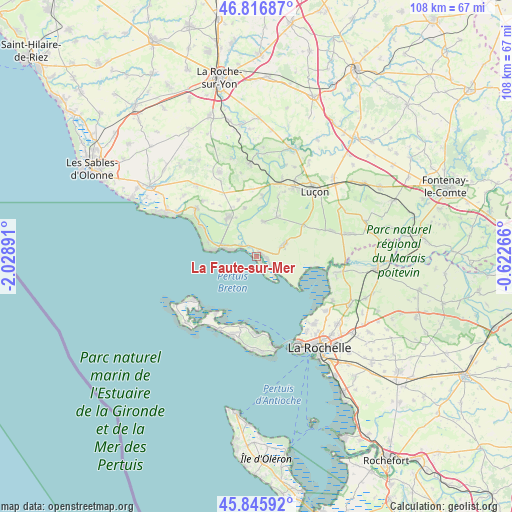
La Faute-sur-Mer GPS coordinates[2]
46° 20' 0.78" North, 1° 19' 32.808" West
| Map corner | latitude | longitude |
|---|---|---|
| Upper-left | 46.81687°, | -2.02891° |
| Center: | 46.33355°, | -1.32578° |
| Lower-right: | 45.84592°, | -0.62266° |
| Map W x H: | 108×108 km | = 67.1×67.1mi |
| max Lat: | 51.07786° ⇑61.9% North |
| La Faute-sur-Mer: | 46.33355° |
| min Lat: | ⇓38.1% South 41.3874° |
| min Long | La Faute-sur-Me | max Long |
| -5.08615° | -1.32578° | 9.52242° |
| W 9%⇐ | ⇒91% E |
Elevation
Elevation of La Faute-sur-Mer is 2 m = 7 ft, and this is 191.7 m = 629 ft below average elevation for this country.
| Max E: |
2333 m = 7654 ft | 99.9% |
| Avg. | 193.7 m = 635 ft | |
| La Faute-sur-Mer | 2 m = 7 ft | |
Min E: |
-1 m = -3 ft | 0.1% |
See also: France elevation on elevation.city.
Geographical zone
La Faute-sur-Mer is located in North temperate zone (between Tropic of Cancer and the Arctic Circle). Distance of this North polar circle is 2249.4 km =1397.7 mi to North.| Distance of | km | miles | from La Faute-sur-Mer |
|---|---|---|---|
| North Pole | 4855.3 | 3016.9 | to North |
| Arctic Circle | 2249.4 | 1397.7 | to North |
| Tropic Cancer | 2545.9 | 1581.9 | to South |
| Equator | 5151.8 | 3201.2 | to South |


Nearby cities:
15 places around La Faute-sur-Mer: (largest is in red/bold)
• Angles
10.3 km =6.4 mi,  324°
324°
• Champagné-les-Marais
16.6 km =10.3 mi,  71°
71°
• Chasnais
15.9 km =9.9 mi,  27°
27°
• Grues
7.4 km =4.6 mi,  12°
12°
• La Couarde-sur-Mer
17.3 km =10.7 mi,  206°
206°
• La Flotte
16.2 km =10.1 mi,  180°
180°
• La Tranche-sur-Mer
8.6 km =5.3 mi,  277°
277°
• Lairoux
13.4 km =8.3 mi,  19°
19°
• Le Bernard
16 km =9.9 mi, 316°
• Le Bois-Plage-en-Ré
17.1 km =10.6 mi,  197°
197°
• Les Portes-en-Ré
16.3 km =10.1 mi,  235°
235°
• Loix
14.5 km =9 mi, 214°
• Longeville-sur-Mer
16.2 km =10.1 mi,  304°
304°
• Saint-Martin-de-Ré
14.8 km =9.2 mi,  192°
192°
• Triaize
11.8 km =7.3 mi,  56°
56°
Sources, notices
• [Note1] Compared only with cities in France existing in our database
• [Src1] Map data: © OpenStreetMap contributors (CC-BY-SA)
• [Src2] Other city data from geonames.org with taken over terms of usage.
• [Src3] Geographical zone / Annual Mean Temperature by Robert A. Rohde @ Wikipedia
