La Tranche-sur-Mer geodata
La Tranche-sur-Mer (Pays de la Loire) is a populated place; located in France in Europe/Paris (GMT+2) time zone. With population of 2,671 people, there are 3652 cities with bigger population in this country. Compared to other cities in France, 61.8% of cities are located further ↑North; 91.8% of cities are located further →East and 98.6% of cities have higher elevation than La Tranche-sur-Mer. Note1
Administrative division(s):
- Level 1: Pays de la Loire
- Level 2: Département de la Vendée
- Level 3: Arrondissement des Sables-d'Olonne
- Level 4: La Tranche-sur-Mer


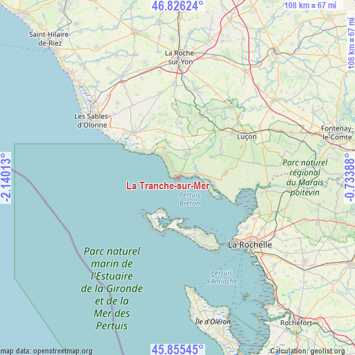
La Tranche-sur-Mer GPS coordinates[2]
46° 20' 34.8" North, 1° 26' 13.2" West
| Map corner | latitude | longitude |
|---|---|---|
| Upper-left | 46.82624°, | -2.14013° |
| Center: | 46.343°, | -1.437° |
| Lower-right: | 45.85545°, | -0.73388° |
| Map W x H: | 107.9×107.9 km | = 67×67mi |
| max Lat: | 51.07786° ⇑61.8% North |
| La Tranche-sur-Mer: | 46.343° |
| min Lat: | ⇓38.2% South 41.3874° |
| min Long | La Tranche-sur- | max Long |
| -5.08615° | -1.437° | 9.52242° |
| W 8.2%⇐ | ⇒91.8% E |
Elevation
Elevation of La Tranche-sur-Mer is 7 m = 23 ft, and this is 186.7 m = 613 ft below average elevation for this country.
| Max E: |
2333 m = 7654 ft | 98.6% |
| Avg. | 193.7 m = 635 ft | |
| La Tranche-sur-Mer | 7 m = 23 ft | |
Min E: |
-1 m = -3 ft | 1.4% |
See also: France elevation on elevation.city.
Geographical zone
La Tranche-sur-Mer is located in North temperate zone (between Tropic of Cancer and the Arctic Circle). Distance of this North polar circle is 2248.3 km =1397 mi to North.| Distance of | km | miles | from La Tranche-sur-Mer |
|---|---|---|---|
| North Pole | 4854.2 | 3016.3 | to North |
| Arctic Circle | 2248.3 | 1397 | to North |
| Tropic Cancer | 2546.9 | 1582.6 | to South |
| Equator | 5152.9 | 3201.9 | to South |


Nearby cities:
15 places around La Tranche-sur-Mer: (largest is in red/bold)
• Angles
7.7 km =4.8 mi,  19°
19°
• Ars-en-Ré
16.8 km =10.4 mi,  204°
204°
• Avrillé
14.3 km =8.9 mi,  346°
346°
• Grues
11.9 km =7.4 mi,  58°
58°
• Jard-sur-Mer
13.3 km =8.3 mi,  306°
306°
• La Couarde-sur-Mer
16.6 km =10.3 mi,  176°
176°
• La Faute-sur-Mer
8.6 km =5.3 mi,  97°
97°
• Le Bernard
10.8 km =6.7 mi, 346°
• Les Portes-en-Ré
11.4 km =7.1 mi,  205°
205°
• Loix
12.9 km =8 mi, 178°
• Longeville-sur-Mer
9.5 km =5.9 mi,  329°
329°
• Moutiers-les-Mauxfaits
15.7 km =9.8 mi,  5°
5°
• Saint-Clément-des-Baleines
15.3 km =9.5 mi, 212°
• Saint-Martin-de-Ré
16.5 km =10.3 mi,  160°
160°
• Saint-Vincent-sur-Jard
12.4 km =7.7 mi, 311°
Sources, notices
• [Note1] Compared only with cities in France existing in our database
• [Src1] Map data: © OpenStreetMap contributors (CC-BY-SA)
• [Src2] Other city data from geonames.org with taken over terms of usage.
• [Src3] Geographical zone / Annual Mean Temperature by Robert A. Rohde @ Wikipedia
