Haucourt geodata
Haucourt (Grand Est) is a populated place; located in France in Europe/Paris (GMT+2) time zone. With population of 2,891 people, there are 3371 cities with bigger population in this country. Compared to other cities in France, 89.1% of cities are located further ↓South; 85.2% of cities are located further ←West and 87.2% of cities have lower elevation than Haucourt. Note1
Administrative division(s):
- Level 1: Grand Est
- Level 2: Meurthe-et-Moselle
- Level 3: Arrondissement de Briey
- Level 4: Haucourt-Moulaine


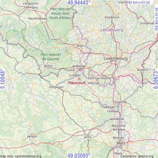
Haucourt GPS coordinates[2]
49° 29' 23.352" North, 5° 48' 12.996" East
| Map corner | latitude | longitude |
|---|---|---|
| Upper-left | 49.94443°, | 5.10048° |
| Center: | 49.48982°, | 5.80361° |
| Lower-right: | 49.03095°, | 6.50673° |
| Map W x H: | 101.6×101.6 km | = 63.1×63.1mi |
| max Lat: | 51.07786° ⇑10.9% North |
| Haucourt: | 49.48982° |
| min Lat: | ⇓89.1% South 41.3874° |
| min Long | Haucourt | max Long |
| -5.08615° | 5.80361° | 9.52242° |
| W 85.2%⇐ | ⇒14.8% E |
Elevation
Elevation of Haucourt is 377 m = 1237 ft, and this is 183.3 m = 601 ft above average elevation for this country.
| Max E: |
2333 m = 7654 ft | 12.8% |
| Haucourt | 377 m 1237 ft | |
| Avg. | 193.7 m = 635 ft | |
Min E: |
-1 m = -3 ft | 87.2% |
See also: France elevation on elevation.city.
Geographical zone
Haucourt is located in North temperate zone (between Tropic of Cancer and the Arctic Circle). Distance of this North polar circle is 1898.4 km =1179.6 mi to North.| Distance of | km | miles | from Haucourt |
|---|---|---|---|
| North Pole | 4504.3 | 2798.8 | to North |
| Arctic Circle | 1898.4 | 1179.6 | to North |
| Tropic Cancer | 2896.8 | 1800 | to South |
| Equator | 5502.8 | 3419.3 | to South |


Nearby cities:
15 places around Haucourt: (largest is in red/bold)
• Baslieux
7 km =4.3 mi,  207°
207°
• Chenières
3.3 km =2.1 mi,  234°
234°
• Cutry
4.4 km =2.7 mi,  260°
260°
• Herserange
3.5 km =2.2 mi,  343°
343°
• Hussigny-Godbrange
4.6 km =2.9 mi,  83°
83°
• Lexy
5.4 km =3.4 mi,  281°
281°
• Longlaville
5 km =3.1 mi,  357°
357°
• Longwy
4.7 km =2.9 mi,  319°
319°
• Mexy
2 km =1.2 mi,  306°
306°
• Mont-Saint-Martin
6.2 km =3.9 mi,  346°
346°
• Morfontaine
5 km =3.1 mi,  174°
174°
• Réhon
3.7 km =2.3 mi,  285°
285°
• Saulnes
4.8 km =3 mi,  15°
15°
• Tiercelet
6.5 km =4 mi,  118°
118°
• Villers-la-Montagne
2.5 km =1.6 mi,  142°
142°
Sources, notices
• [Note1] Compared only with cities in France existing in our database
• [Src1] Map data: © OpenStreetMap contributors (CC-BY-SA)
• [Src2] Other city data from geonames.org with taken over terms of usage.
• [Src3] Geographical zone / Annual Mean Temperature by Robert A. Rohde @ Wikipedia
