Hardinghen geodata
Hardinghen (Hauts-de-France) is a populated place; located in France in Europe/Paris (GMT+2) time zone. With population of 1,030 people, there are 8614 cities with bigger population in this country. Compared to other cities in France, 99.3% of cities are located further ↓South; 59.2% of cities are located further →East and 55.6% of cities have higher elevation than Hardinghen. Note1
Administrative division(s):
- Level 1: Hauts-de-France
- Level 2: Pas-de-Calais
- Level 3: Arrondissement de Calais
- Level 4: Hardinghen


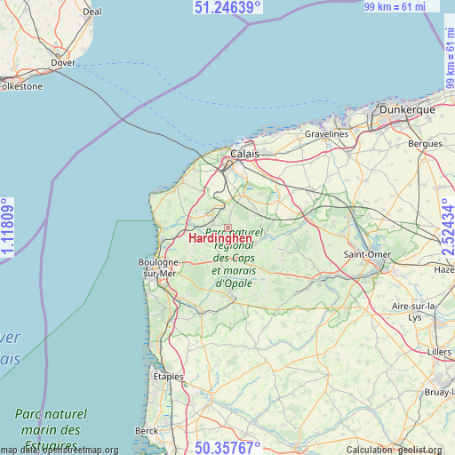
Hardinghen GPS coordinates[2]
50° 48' 14.904" North, 1° 49' 16.392" East
| Map corner | latitude | longitude |
|---|---|---|
| Upper-left | 51.24639°, | 1.11809° |
| Center: | 50.80414°, | 1.82122° |
| Lower-right: | 50.35767°, | 2.52434° |
| Map W x H: | 98.8×98.8 km | = 61.4×61.4mi |
| max Lat: | 51.07786° ⇑0.7% North |
| Hardinghen: | 50.80414° |
| min Lat: | ⇓99.3% South 41.3874° |
| min Long | Hardinghen | max Long |
| -5.08615° | 1.82122° | 9.52242° |
| W 40.8%⇐ | ⇒59.2% E |
Elevation
Elevation of Hardinghen is 115 m = 377 ft, and this is 78.7 m = 258 ft below average elevation for this country.
| Max E: |
2333 m = 7654 ft | 55.6% |
| Avg. | 193.7 m = 635 ft | |
| Hardinghen | 115 m = 377 ft | |
Min E: |
-1 m = -3 ft | 44.4% |
See also: France elevation on elevation.city.
Geographical zone
Hardinghen is located in North temperate zone (between Tropic of Cancer and the Arctic Circle). Distance of this North polar circle is 1752.3 km =1088.8 mi to North.| Distance of | km | miles | from Hardinghen |
|---|---|---|---|
| North Pole | 4358.2 | 2708.1 | to North |
| Arctic Circle | 1752.3 | 1088.8 | to North |
| Tropic Cancer | 3043 | 1890.8 | to South |
| Equator | 5648.9 | 3510.1 | to South |


Nearby cities:
15 places around Hardinghen: (largest is in red/bold)
• Andres
9.8 km =6.1 mi,  45°
45°
• Belle-et-Houllefort
8 km =5 mi,  213°
213°
• Bouquehault
6.2 km =3.9 mi,  67°
67°
• Colembert
6.8 km =4.2 mi,  166°
166°
• Ferques
5.2 km =3.2 mi,  303°
303°
• Fiennes
2.6 km =1.6 mi,  6°
6°
• Guînes
7.8 km =4.8 mi,  26°
26°
• Hames-Boucres
8.8 km =5.5 mi, 10°
• Landrethun-le-Nord
5.5 km =3.4 mi,  331°
331°
• Licques
8.5 km =5.3 mi,  105°
105°
• Marquise
8 km =5 mi,  277°
277°
• Rety
3.9 km =2.4 mi,  263°
263°
• Rinxent
6.5 km =4 mi,  272°
272°
• Saint-Inglevert
9.6 km =6 mi, 325°
• Wierre-Effroy
6.6 km =4.1 mi,  244°
244°
Sources, notices
• [Note1] Compared only with cities in France existing in our database
• [Src1] Map data: © OpenStreetMap contributors (CC-BY-SA)
• [Src2] Other city data from geonames.org with taken over terms of usage.
• [Src3] Geographical zone / Annual Mean Temperature by Robert A. Rohde @ Wikipedia
