Fiennes geodata
Fiennes (Hauts-de-France) is a populated place; located in France in Europe/Paris (GMT+2) time zone. With population of 829 people, there are 10301 cities with bigger population in this country. Compared to other cities in France, 99.4% of cities are located further ↓South; 59.1% of cities are located further →East and 65.6% of cities have higher elevation than Fiennes. Note1
Administrative division(s):
- Level 1: Hauts-de-France
- Level 2: Pas-de-Calais
- Level 3: Arrondissement de Calais
- Level 4: Fiennes


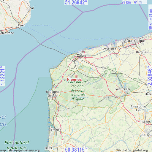
Fiennes GPS coordinates[2]
50° 49' 38.64" North, 1° 49' 31.188" East
| Map corner | latitude | longitude |
|---|---|---|
| Upper-left | 51.26942°, | 1.12221° |
| Center: | 50.8274°, | 1.82533° |
| Lower-right: | 50.38115°, | 2.52846° |
| Map W x H: | 98.8×98.8 km | = 61.4×61.4mi |
| max Lat: | 51.07786° ⇑0.6% North |
| Fiennes: | 50.8274° |
| min Lat: | ⇓99.4% South 41.3874° |
| min Long | Fiennes | max Long |
| -5.08615° | 1.82533° | 9.52242° |
| W 40.9%⇐ | ⇒59.1% E |
Elevation
Elevation of Fiennes is 88 m = 289 ft, and this is 105.7 m = 347 ft below average elevation for this country.
| Max E: |
2333 m = 7654 ft | 65.6% |
| Avg. | 193.7 m = 635 ft | |
| Fiennes | 88 m = 289 ft | |
Min E: |
-1 m = -3 ft | 34.4% |
See also: France elevation on elevation.city.
Geographical zone
Fiennes is located in North temperate zone (between Tropic of Cancer and the Arctic Circle). Distance of this North polar circle is 1749.7 km =1087.2 mi to North.| Distance of | km | miles | from Fiennes |
|---|---|---|---|
| North Pole | 4355.6 | 2706.4 | to North |
| Arctic Circle | 1749.7 | 1087.2 | to North |
| Tropic Cancer | 3045.6 | 1892.4 | to South |
| Equator | 5651.5 | 3511.7 | to South |


Nearby cities:
15 places around Fiennes: (largest is in red/bold)
• Andres
7.9 km =4.9 mi,  57°
57°
• Balinghem
9.1 km =5.7 mi,  65°
65°
• Bonningues-lès-Calais
7.9 km =4.9 mi,  332°
332°
• Bouquehault
5.4 km =3.4 mi,  91°
91°
• Ferques
4.6 km =2.9 mi,  273°
273°
• Guînes
5.4 km =3.4 mi,  35°
35°
• Hames-Boucres
6.2 km =3.9 mi,  11°
11°
• Hardinghen
2.6 km =1.6 mi,  186°
186°
• Landrethun-le-Nord
3.7 km =2.3 mi,  307°
307°
• Marquise
8.4 km =5.2 mi,  258°
258°
• Rety
5.1 km =3.2 mi,  233°
233°
• Rinxent
7.1 km =4.4 mi,  251°
251°
• Saint-Inglevert
7.8 km =4.8 mi, 313°
• Saint-Tricat
7.3 km =4.5 mi,  3°
3°
• Wierre-Effroy
8.3 km =5.2 mi, 228°
Sources, notices
• [Note1] Compared only with cities in France existing in our database
• [Src1] Map data: © OpenStreetMap contributors (CC-BY-SA)
• [Src2] Other city data from geonames.org with taken over terms of usage.
• [Src3] Geographical zone / Annual Mean Temperature by Robert A. Rohde @ Wikipedia
