Guipel geodata
Guipel (Brittany) is a populated place; located in France in Europe/Paris (GMT+2) time zone. With population of 1,557 people, there are 5984 cities with bigger population in this country. Compared to other cities in France, 64.5% of cities are located further ↓South; 93.6% of cities are located further →East and 71.4% of cities have higher elevation than Guipel. Note1
Administrative division(s):
- Level 1: Brittany
- Level 2: Département d'Ille-et-Vilaine
- Level 3: Arrondissement de Rennes
- Level 4: Guipel


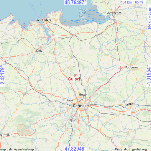
Guipel GPS coordinates[2]
48° 17' 57.732" North, 1° 43' 7.176" West
| Map corner | latitude | longitude |
|---|---|---|
| Upper-left | 48.76497°, | -2.42179° |
| Center: | 48.29937°, | -1.71866° |
| Lower-right: | 47.82948°, | -1.01554° |
| Map W x H: | 104×104 km | = 64.6×64.6mi |
| max Lat: | 51.07786° ⇑35.5% North |
| Guipel: | 48.29937° |
| min Lat: | ⇓64.5% South 41.3874° |
| min Long | Guipel | max Long |
| -5.08615° | -1.71866° | 9.52242° |
| W 6.4%⇐ | ⇒93.6% E |
Elevation
Elevation of Guipel is 75 m = 246 ft, and this is 118.7 m = 389 ft below average elevation for this country.
| Max E: |
2333 m = 7654 ft | 71.4% |
| Avg. | 193.7 m = 635 ft | |
| Guipel | 75 m = 246 ft | |
Min E: |
-1 m = -3 ft | 28.6% |
See also: France elevation on elevation.city.
Geographical zone
Guipel is located in North temperate zone (between Tropic of Cancer and the Arctic Circle). Distance of this North polar circle is 2030.8 km =1261.9 mi to North.| Distance of | km | miles | from Guipel |
|---|---|---|---|
| North Pole | 4636.7 | 2881.1 | to North |
| Arctic Circle | 2030.8 | 1261.9 | to North |
| Tropic Cancer | 2764.5 | 1717.8 | to South |
| Equator | 5370.4 | 3337 | to South |


Nearby cities:
15 places around Guipel: (largest is in red/bold)
• Andouillé-Neuville
9.6 km =6 mi,  94°
94°
• Dingé
6.4 km =4 mi,  2°
2°
• Feins
6.6 km =4.1 mi,  60°
60°
• Hédé-Bazouges
6 km =3.7 mi,  270°
270°
• La Mézière
9.4 km =5.8 mi,  196°
196°
• Langouet
9.6 km =6 mi,  234°
234°
• Melesse
9.2 km =5.7 mi,  169°
169°
• Montreuil-le-Gast
5.9 km =3.7 mi,  184°
184°
• Montreuil-sur-Ille
3.8 km =2.4 mi,  75°
75°
• Québriac
9.5 km =5.9 mi,  301°
301°
• Saint-Germain-sur-Ille
7.1 km =4.4 mi,  141°
141°
• Saint-Gondran
9.4 km =5.8 mi,  247°
247°
• Saint-Médard-sur-Ille
5.3 km =3.3 mi,  124°
124°
• Tinténiac
9.3 km =5.8 mi,  290°
290°
• Vignoc
7.3 km =4.5 mi,  219°
219°
Sources, notices
• [Note1] Compared only with cities in France existing in our database
• [Src1] Map data: © OpenStreetMap contributors (CC-BY-SA)
• [Src2] Other city data from geonames.org with taken over terms of usage.
• [Src3] Geographical zone / Annual Mean Temperature by Robert A. Rohde @ Wikipedia
