Dingé geodata
Dingé (Brittany) is a populated place; located in France in Europe/Paris (GMT+2) time zone. With population of 1,452 people, there are 6369 cities with bigger population in this country. Compared to other cities in France, 65.6% of cities are located further ↓South; 93.6% of cities are located further →East and 65.3% of cities have higher elevation than Dingé. Note1
Administrative division(s):
- Level 1: Brittany
- Level 2: Département d'Ille-et-Vilaine
- Level 3: Arrondissement de Saint-Malo
- Level 4: Dingé


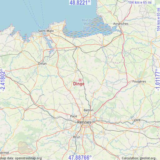
Dingé GPS coordinates[2]
48° 21' 25.272" North, 1° 42' 53.604" West
| Map corner | latitude | longitude |
|---|---|---|
| Upper-left | 48.8221°, | -2.41802° |
| Center: | 48.35702°, | -1.71489° |
| Lower-right: | 47.88766°, | -1.01177° |
| Map W x H: | 103.9×103.9 km | = 64.6×64.6mi |
| max Lat: | 51.07786° ⇑34.4% North |
| Dingé: | 48.35702° |
| min Lat: | ⇓65.6% South 41.3874° |
| min Long | Dingé | max Long |
| -5.08615° | -1.71489° | 9.52242° |
| W 6.4%⇐ | ⇒93.6% E |
Elevation
Elevation of Dingé is 89 m = 292 ft, and this is 104.7 m = 344 ft below average elevation for this country.
| Max E: |
2333 m = 7654 ft | 65.3% |
| Avg. | 193.7 m = 635 ft | |
| Dingé | 89 m = 292 ft | |
Min E: |
-1 m = -3 ft | 34.7% |
See also: France elevation on elevation.city.
Geographical zone
Dingé is located in North temperate zone (between Tropic of Cancer and the Arctic Circle). Distance of this North polar circle is 2024.4 km =1257.9 mi to North.| Distance of | km | miles | from Dingé |
|---|---|---|---|
| North Pole | 4630.3 | 2877.1 | to North |
| Arctic Circle | 2024.4 | 1257.9 | to North |
| Tropic Cancer | 2770.9 | 1721.8 | to South |
| Equator | 5376.8 | 3341 | to South |


Nearby cities:
15 places around Dingé: (largest is in red/bold)
• Andouillé-Neuville
11.7 km =7.3 mi,  127°
127°
• Combourg
6.6 km =4.1 mi,  340°
340°
• Feins
6.3 km =3.9 mi,  120°
120°
• Guipel
6.4 km =4 mi,  182°
182°
• Hédé-Bazouges
8.9 km =5.5 mi,  224°
224°
• Marcillé-Raoul
8.6 km =5.3 mi,  69°
69°
• Meillac
9.5 km =5.9 mi,  309°
309°
• Montreuil-le-Gast
12.3 km =7.6 mi, 183°
• Montreuil-sur-Ille
6.4 km =4 mi,  148°
148°
• Québriac
8.4 km =5.2 mi,  260°
260°
• Saint-Domineuc
12 km =7.5 mi,  277°
277°
• Saint-Germain-sur-Ille
12.7 km =7.9 mi,  160°
160°
• Saint-Médard-sur-Ille
10.3 km =6.4 mi, 156°
• Saint-Rémy-du-Plain
11 km =6.8 mi,  84°
84°
• Tinténiac
9.5 km =5.9 mi,  250°
250°
Sources, notices
• [Note1] Compared only with cities in France existing in our database
• [Src1] Map data: © OpenStreetMap contributors (CC-BY-SA)
• [Src2] Other city data from geonames.org with taken over terms of usage.
• [Src3] Geographical zone / Annual Mean Temperature by Robert A. Rohde @ Wikipedia
