Guerlesquin geodata
Guerlesquin (Brittany) is a populated place; located in France in Europe/Paris (GMT+2) time zone. With population of 1,451 people, there are 6376 cities with bigger population in this country. Compared to other cities in France, 68.8% of cities are located further ↓South; 98.5% of cities are located further →East and 65.8% of cities have lower elevation than Guerlesquin. Note1
Administrative division(s):
- Level 1: Brittany
- Level 2: Département du Finistère
- Level 3: Arrondissement de Morlaix
- Level 4: Guerlesquin


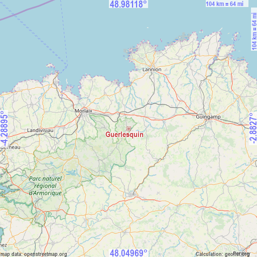
Guerlesquin GPS coordinates[2]
48° 31' 3.288" North, 3° 35' 8.988" West
| Map corner | latitude | longitude |
|---|---|---|
| Upper-left | 48.98118°, | -4.28895° |
| Center: | 48.51758°, | -3.58583° |
| Lower-right: | 48.04969°, | -2.8827° |
| Map W x H: | 103.6×103.6 km | = 64.4×64.4mi |
| max Lat: | 51.07786° ⇑31.2% North |
| Guerlesquin: | 48.51758° |
| min Lat: | ⇓68.8% South 41.3874° |
| min Long | Guerlesquin | max Long |
| -5.08615° | -3.58583° | 9.52242° |
| W 1.5%⇐ | ⇒98.5% E |
Elevation
Elevation of Guerlesquin is 198 m = 650 ft, and this is 4.3 m = 14 ft above average elevation for this country.
| Max E: |
2333 m = 7654 ft | 34.2% |
| Guerlesquin | 198 m 650 ft | |
| Avg. | 193.7 m = 635 ft | |
Min E: |
-1 m = -3 ft | 65.8% |
See also: France elevation on elevation.city.
Geographical zone
Guerlesquin is located in North temperate zone (between Tropic of Cancer and the Arctic Circle). Distance of this North polar circle is 2006.5 km =1246.8 mi to North.| Distance of | km | miles | from Guerlesquin |
|---|---|---|---|
| North Pole | 4612.4 | 2866 | to North |
| Arctic Circle | 2006.5 | 1246.8 | to North |
| Tropic Cancer | 2788.7 | 1732.8 | to South |
| Equator | 5394.6 | 3352 | to South |


Nearby cities:
15 places around Guerlesquin: (largest is in red/bold)
• Belle-Isle-en-Terre
14.4 km =8.9 mi,  77°
77°
• Botsorhel
4.1 km =2.5 mi,  285°
285°
• Lanvellec
11.9 km =7.4 mi,  17°
17°
• Le Vieux-Marché
13.6 km =8.5 mi,  47°
47°
• Loguivy-Plougras
7.3 km =4.5 mi,  85°
85°
• Plouaret
14.1 km =8.8 mi,  38°
38°
• Plougonven
9.6 km =6 mi,  269°
269°
• Plougras
1.4 km =0.9 mi, 94°
• Plouigneau
10 km =6.2 mi,  303°
303°
• Plounérin
6.7 km =4.2 mi, 35°
• Plounévez-Moëdec
11.4 km =7.1 mi,  61°
61°
• Plouégat-Guérand
12.5 km =7.8 mi,  331°
331°
• Plouégat-Moysan
5.9 km =3.7 mi,  337°
337°
• Plufur
9.3 km =5.8 mi,  8°
8°
• Scrignac
11.6 km =7.2 mi,  216°
216°
Sources, notices
• [Note1] Compared only with cities in France existing in our database
• [Src1] Map data: © OpenStreetMap contributors (CC-BY-SA)
• [Src2] Other city data from geonames.org with taken over terms of usage.
• [Src3] Geographical zone / Annual Mean Temperature by Robert A. Rohde @ Wikipedia
