Guemps geodata
Guemps (Hauts-de-France) is a populated place; located in France in Europe/Paris (GMT+2) time zone. With population of 903 people, there are 9626 cities with bigger population in this country. Compared to other cities in France, 99.7% of cities are located further ↓South; 57.2% of cities are located further →East and 100% of cities have higher elevation than Guemps. Note1
Administrative division(s):
- Level 1: Hauts-de-France
- Level 2: Pas-de-Calais
- Level 3: Arrondissement de Calais
- Level 4: Guemps


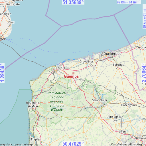
Guemps GPS coordinates[2]
50° 54' 56.52" North, 1° 59' 51.072" East
| Map corner | latitude | longitude |
|---|---|---|
| Upper-left | 51.35689°, | 1.29439° |
| Center: | 50.9157°, | 1.99752° |
| Lower-right: | 50.47029°, | 2.70064° |
| Map W x H: | 98.6×98.6 km | = 61.3×61.3mi |
| max Lat: | 51.07786° ⇑0.3% North |
| Guemps: | 50.9157° |
| min Lat: | ⇓99.7% South 41.3874° |
| min Long | Guemps | max Long |
| -5.08615° | 1.99752° | 9.52242° |
| W 42.8%⇐ | ⇒57.2% E |
Elevation
Elevation of Guemps is 1 m = 3 ft, and this is 192.7 m = 632 ft below average elevation for this country.
| Max E: |
2333 m = 7654 ft | 100% |
| Avg. | 193.7 m = 635 ft | |
| Guemps | 1 m = 3 ft | |
Min E: |
-1 m = -3 ft | 0% |
See also: France elevation on elevation.city.
Geographical zone
Guemps is located in North temperate zone (between Tropic of Cancer and the Arctic Circle). Distance of this North polar circle is 1739.9 km =1081.1 mi to North.| Distance of | km | miles | from Guemps |
|---|---|---|---|
| North Pole | 4345.8 | 2700.4 | to North |
| Arctic Circle | 1739.9 | 1081.1 | to North |
| Tropic Cancer | 3055.4 | 1898.5 | to South |
| Equator | 5661.3 | 3517.8 | to South |


Nearby cities:
15 places around Guemps: (largest is in red/bold)
• Andres
7.7 km =4.8 mi,  223°
223°
• Ardres
6.5 km =4 mi,  189°
189°
• Audruicq
7.1 km =4.4 mi,  126°
126°
• Balinghem
7.2 km =4.5 mi,  211°
211°
• Brêmes
6.9 km =4.3 mi, 192°
• Coulogne
8.2 km =5.1 mi,  276°
276°
• Les Attaques
4.8 km =3 mi,  261°
261°
• Marck
5.3 km =3.3 mi,  314°
314°
• Nortkerque
4.9 km =3 mi,  157°
157°
• Offekerque
3.3 km =2.1 mi,  28°
28°
• Oye-Plage
7.5 km =4.7 mi,  24°
24°
• Saint-Folquin
9.5 km =5.9 mi,  70°
70°
• Saint-Omer-Capelle
7.8 km =4.8 mi, 70°
• Vieille-Église
5.7 km =3.5 mi,  75°
75°
• Zutkerque
8.6 km =5.3 mi,  144°
144°
Sources, notices
• [Note1] Compared only with cities in France existing in our database
• [Src1] Map data: © OpenStreetMap contributors (CC-BY-SA)
• [Src2] Other city data from geonames.org with taken over terms of usage.
• [Src3] Geographical zone / Annual Mean Temperature by Robert A. Rohde @ Wikipedia
