Marck geodata
Marck (Hauts-de-France) is a populated place; located in France in Europe/Paris (GMT+2) time zone. With population of 9,158 people, there are 1047 cities with bigger population in this country. Compared to other cities in France, 99.8% of cities are located further ↓South; 57.8% of cities are located further →East and 99.6% of cities have higher elevation than Marck. Note1
Administrative division(s):
- Level 1: Hauts-de-France
- Level 2: Pas-de-Calais
- Level 3: Arrondissement de Calais
- Level 4: Marck


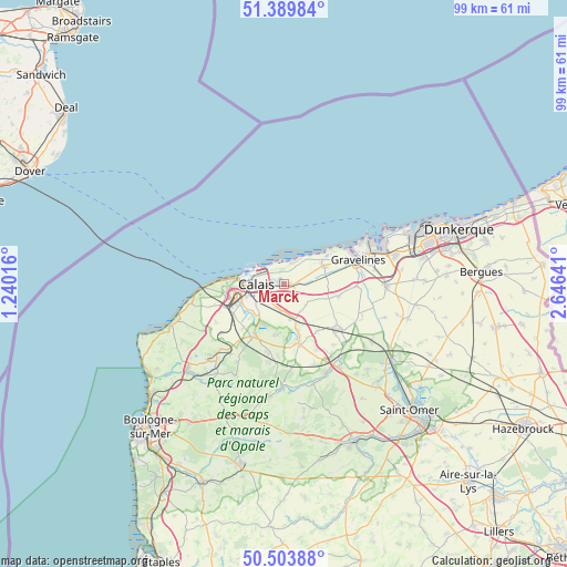
Marck GPS coordinates[2]
50° 56' 56.292" North, 1° 56' 35.808" East
| Map corner | latitude | longitude |
|---|---|---|
| Upper-left | 51.38984°, | 1.24016° |
| Center: | 50.94897°, | 1.94328° |
| Lower-right: | 50.50388°, | 2.64641° |
| Map W x H: | 98.5×98.5 km | = 61.2×61.2mi |
| max Lat: | 51.07786° ⇑0.2% North |
| Marck: | 50.94897° |
| min Lat: | ⇓99.8% South 41.3874° |
| min Long | Marck | max Long |
| -5.08615° | 1.94328° | 9.52242° |
| W 42.2%⇐ | ⇒57.8% E |
Elevation
Elevation of Marck is 4 m = 13 ft, and this is 189.7 m = 622 ft below average elevation for this country.
| Max E: |
2333 m = 7654 ft | 99.6% |
| Avg. | 193.7 m = 635 ft | |
| Marck | 4 m = 13 ft | |
Min E: |
-1 m = -3 ft | 0.4% |
See also: France elevation on elevation.city.
Geographical zone
Marck is located in North temperate zone (between Tropic of Cancer and the Arctic Circle). Distance of this North polar circle is 1736.2 km =1078.8 mi to North.| Distance of | km | miles | from Marck |
|---|---|---|---|
| North Pole | 4342.1 | 2698.1 | to North |
| Arctic Circle | 1736.2 | 1078.8 | to North |
| Tropic Cancer | 3059.1 | 1900.8 | to South |
| Equator | 5665 | 3520.1 | to South |


Nearby cities:
15 places around Marck: (largest is in red/bold)
• Andres
9.4 km =5.8 mi,  189°
189°
• Balinghem
9.8 km =6.1 mi,  179°
179°
• Calais
6.1 km =3.8 mi,  273°
273°
• Coquelles
10.2 km =6.3 mi,  261°
261°
• Coulogne
5.1 km =3.2 mi,  238°
238°
• Fréthun
9 km =5.6 mi,  246°
246°
• Guemps
5.3 km =3.3 mi,  134°
134°
• Guînes
10.4 km =6.5 mi,  209°
209°
• Hames-Boucres
10.2 km =6.3 mi,  223°
223°
• Les Attaques
4.5 km =2.8 mi, 192°
• Nortkerque
10 km =6.2 mi,  145°
145°
• Offekerque
5.4 km =3.4 mi,  98°
98°
• Oye-Plage
7.6 km =4.7 mi,  65°
65°
• Saint-Tricat
10 km =6.2 mi,  231°
231°
• Vieille-Église
9.6 km =6 mi, 103°
Sources, notices
• [Note1] Compared only with cities in France existing in our database
• [Src1] Map data: © OpenStreetMap contributors (CC-BY-SA)
• [Src2] Other city data from geonames.org with taken over terms of usage.
• [Src3] Geographical zone / Annual Mean Temperature by Robert A. Rohde @ Wikipedia
