Gigean geodata
Gigean (Occitanie) is a populated place; located in France in Europe/Paris (GMT+2) time zone. With population of 3,977 people, there are 2476 cities with bigger population in this country. Compared to other cities in France, 93.1% of cities are located further ↑North; 65.8% of cities are located further ←West and 85.3% of cities have higher elevation than Gigean. Note1
Administrative division(s):
- Level 1: Occitanie
- Level 2: Département de l'Hérault
- Level 3: Arrondissement of Montpellier
- Level 4: Gigean


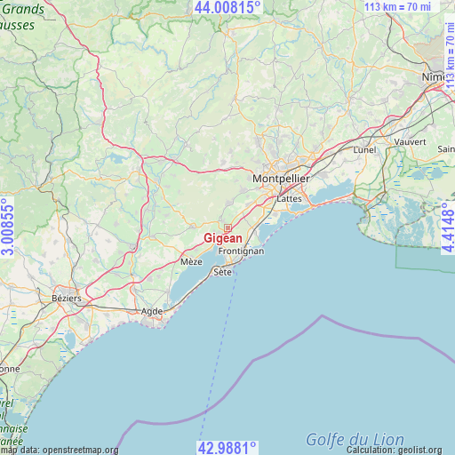
Gigean GPS coordinates[2]
43° 30' 1.008" North, 3° 42' 42.012" East
| Map corner | latitude | longitude |
|---|---|---|
| Upper-left | 44.00815°, | 3.00855° |
| Center: | 43.50028°, | 3.71167° |
| Lower-right: | 42.9881°, | 4.4148° |
| Map W x H: | 113.4×113.4 km | = 70.5×70.5mi |
| max Lat: | 51.07786° ⇑93.1% North |
| Gigean: | 43.50028° |
| min Lat: | ⇓6.9% South 41.3874° |
| min Long | Gigean | max Long |
| -5.08615° | 3.71167° | 9.52242° |
| W 65.8%⇐ | ⇒34.2% E |
Elevation
Elevation of Gigean is 41 m = 135 ft, and this is 152.7 m = 501 ft below average elevation for this country.
| Max E: |
2333 m = 7654 ft | 85.3% |
| Avg. | 193.7 m = 635 ft | |
| Gigean | 41 m = 135 ft | |
Min E: |
-1 m = -3 ft | 14.7% |
See also: France elevation on elevation.city.
Geographical zone
Gigean is located in North temperate zone (between Tropic of Cancer and the Arctic Circle). Distance of this Northern Tropic circle is 2230.9 km =1386.2 mi to South.| Distance of | km | miles | from Gigean |
|---|---|---|---|
| North Pole | 5170.3 | 3212.7 | to North |
| Arctic Circle | 2564.4 | 1593.4 | to North |
| Tropic Cancer | 2230.9 | 1386.2 | to South |
| Equator | 4836.8 | 3005.4 | to South |


Nearby cities:
15 places around Gigean: (largest is in red/bold)
• Balaruc-le-Vieux
4.8 km =3 mi,  206°
206°
• Balaruc-les-Bains
7.1 km =4.4 mi,  202°
202°
• Bouzigues
7.2 km =4.5 mi,  216°
216°
• Cournonsec
5.5 km =3.4 mi,  354°
354°
• Cournonterral
6.6 km =4.1 mi,  5°
5°
• Fabrègues
7.6 km =4.7 mi,  43°
43°
• Frontignan
6.7 km =4.2 mi,  149°
149°
• Loupian
9.7 km =6 mi,  234°
234°
• Mireval
7.3 km =4.5 mi,  82°
82°
• Montbazin
2.2 km =1.4 mi,  326°
326°
• Pignan
10 km =6.2 mi,  22°
22°
• Poussan
3.5 km =2.2 mi,  249°
249°
• Saussan
9.5 km =5.9 mi,  32°
32°
• Vic-la-Gardiole
7 km =4.3 mi,  98°
98°
• Villeveyrac
8.4 km =5.2 mi,  270°
270°
Sources, notices
• [Note1] Compared only with cities in France existing in our database
• [Src1] Map data: © OpenStreetMap contributors (CC-BY-SA)
• [Src2] Other city data from geonames.org with taken over terms of usage.
• [Src3] Geographical zone / Annual Mean Temperature by Robert A. Rohde @ Wikipedia
