Fabrègues geodata
Fabrègues (Occitanie) is a populated place; located in France in Europe/Paris (GMT+2) time zone. With population of 6,607 people, there are 1494 cities with bigger population in this country. Compared to other cities in France, 92.4% of cities are located further ↑North; 66.2% of cities are located further ←West and 84.9% of cities have higher elevation than Fabrègues. Note1
Administrative division(s):
- Level 1: Occitanie
- Level 2: Département de l'Hérault
- Level 3: Arrondissement of Montpellier
- Level 4: Fabrègues


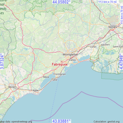
Fabrègues GPS coordinates[2]
43° 33' 2.052" North, 3° 46' 34.932" East
| Map corner | latitude | longitude |
|---|---|---|
| Upper-left | 44.05802°, | 3.07324° |
| Center: | 43.55057°, | 3.77637° |
| Lower-right: | 43.03881°, | 4.47949° |
| Map W x H: | 113.3×113.3 km | = 70.4×70.4mi |
| max Lat: | 51.07786° ⇑92.4% North |
| Fabrègues: | 43.55057° |
| min Lat: | ⇓7.6% South 41.3874° |
| min Long | Fabrègues | max Long |
| -5.08615° | 3.77637° | 9.52242° |
| W 66.2%⇐ | ⇒33.8% E |
Elevation
Elevation of Fabrègues is 42 m = 138 ft, and this is 151.7 m = 498 ft below average elevation for this country.
| Max E: |
2333 m = 7654 ft | 84.9% |
| Avg. | 193.7 m = 635 ft | |
| Fabrègues | 42 m = 138 ft | |
Min E: |
-1 m = -3 ft | 15.1% |
See also: France elevation on elevation.city.
Geographical zone
Fabrègues is located in North temperate zone (between Tropic of Cancer and the Arctic Circle). Distance of this Northern Tropic circle is 2236.5 km =1389.7 mi to South.| Distance of | km | miles | from Fabrègues |
|---|---|---|---|
| North Pole | 5164.7 | 3209.2 | to North |
| Arctic Circle | 2558.8 | 1590 | to North |
| Tropic Cancer | 2236.5 | 1389.7 | to South |
| Equator | 4842.4 | 3008.9 | to South |


Nearby cities:
15 places around Fabrègues: (largest is in red/bold)
• Cournonsec
5.7 km =3.5 mi,  268°
268°
• Cournonterral
4.6 km =2.9 mi,  281°
281°
• Gigean
7.6 km =4.7 mi,  223°
223°
• Juvignac
7.6 km =4.7 mi,  21°
21°
• Lattes
10.5 km =6.5 mi,  79°
79°
• Lavérune
4.6 km =2.9 mi,  31°
31°
• Mireval
5.1 km =3.2 mi,  156°
156°
• Montbazin
7.4 km =4.6 mi,  239°
239°
• Montpellier
10.5 km =6.5 mi,  50°
50°
• Murviel-lès-Montpellier
6.8 km =4.2 mi,  332°
332°
• Pignan
3.9 km =2.4 mi,  340°
340°
• Saint-Jean-de-Védas
5 km =3.1 mi, 53°
• Saussan
2.4 km =1.5 mi,  357°
357°
• Vic-la-Gardiole
6.9 km =4.3 mi,  165°
165°
• Villeneuve-lès-Maguelone
7.5 km =4.7 mi,  104°
104°
Sources, notices
• [Note1] Compared only with cities in France existing in our database
• [Src1] Map data: © OpenStreetMap contributors (CC-BY-SA)
• [Src2] Other city data from geonames.org with taken over terms of usage.
• [Src3] Geographical zone / Annual Mean Temperature by Robert A. Rohde @ Wikipedia
