Genay geodata
Genay (Auvergne-Rhône-Alpes) is a populated place; located in France in Europe/Paris (GMT+2) time zone. With population of 4,729 people, there are 2095 cities with bigger population in this country. Compared to other cities in France, 67.7% of cities are located further ↑North; 75.7% of cities are located further ←West and 74.9% of cities have lower elevation than Genay. Note1
Administrative division(s):
- Level 1: Auvergne-Rhône-Alpes
- Level 2: Département du Rhône
- Level 3: Arrondissement de Lyon
- Level 4: Genay


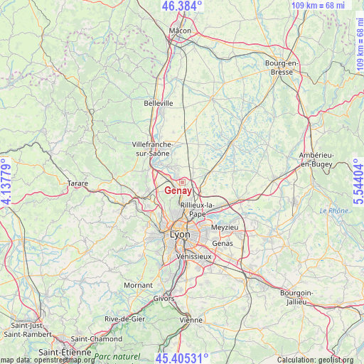
Genay GPS coordinates[2]
45° 53' 48.516" North, 4° 50' 27.276" East
| Map corner | latitude | longitude |
|---|---|---|
| Upper-left | 46.384°, | 4.13779° |
| Center: | 45.89681°, | 4.84091° |
| Lower-right: | 45.40531°, | 5.54404° |
| Map W x H: | 108.8×108.8 km | = 67.6×67.6mi |
| max Lat: | 51.07786° ⇑67.7% North |
| Genay: | 45.89681° |
| min Lat: | ⇓32.3% South 41.3874° |
| min Long | Genay | max Long |
| -5.08615° | 4.84091° | 9.52242° |
| W 75.7%⇐ | ⇒24.3% E |
Elevation
Elevation of Genay is 248 m = 814 ft, and this is 54.3 m = 178 ft above average elevation for this country.
| Max E: |
2333 m = 7654 ft | 25.1% |
| Genay | 248 m 814 ft | |
| Avg. | 193.7 m = 635 ft | |
Min E: |
-1 m = -3 ft | 74.9% |
See also: France elevation on elevation.city.
Geographical zone
Genay is located in North temperate zone (between Tropic of Cancer and the Arctic Circle). Distance of this North polar circle is 2297.9 km =1427.8 mi to North.| Distance of | km | miles | from Genay |
|---|---|---|---|
| North Pole | 4903.8 | 3047.1 | to North |
| Arctic Circle | 2297.9 | 1427.8 | to North |
| Tropic Cancer | 2497.3 | 1551.7 | to South |
| Equator | 5103.2 | 3171 | to South |


Nearby cities:
15 places around Genay: (largest is in red/bold)
• Albigny-sur-Saône
3.4 km =2.1 mi,  189°
189°
• Cailloux-sur-Fontaines
5.6 km =3.5 mi,  151°
151°
• Chasselay
5.9 km =3.7 mi,  244°
244°
• Civrieux
4.2 km =2.6 mi,  50°
50°
• Couzon-au-Mont-d’Or
5.9 km =3.7 mi, 189°
• Fleurieu-sur-Saône
4 km =2.5 mi,  173°
173°
• Fontaines-Saint-Martin
5.9 km =3.7 mi, 170°
• Massieux
1.6 km =1 mi,  336°
336°
• Mionnay
6.7 km =4.2 mi,  88°
88°
• Montanay
2.6 km =1.6 mi,  138°
138°
• Neuville-sur-Saône
2.3 km =1.4 mi,  179°
179°
• Parcieux
2.6 km =1.6 mi,  329°
329°
• Quincieux
5.3 km =3.3 mi,  290°
290°
• Reyrieux
4.8 km =3 mi, 334°
• Rochetaillée-sur-Saône
5.3 km =3.3 mi, 172°
Sources, notices
• [Note1] Compared only with cities in France existing in our database
• [Src1] Map data: © OpenStreetMap contributors (CC-BY-SA)
• [Src2] Other city data from geonames.org with taken over terms of usage.
• [Src3] Geographical zone / Annual Mean Temperature by Robert A. Rohde @ Wikipedia
