Étaules geodata
Étaules (Nouvelle-Aquitaine) is a populated place; located in France in Europe/Paris (GMT+2) time zone. With population of 2,009 people, there are 4777 cities with bigger population in this country. Compared to other cities in France, 70.3% of cities are located further ↑North; 89.1% of cities are located further →East and 92.7% of cities have higher elevation than Étaules. Note1
Administrative division(s):
- Level 1: Nouvelle-Aquitaine
- Level 2: Charente-Maritime
- Level 3: Arrondissement de Rochefort
- Level 4: Étaules


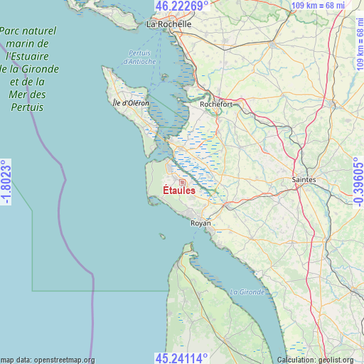
Étaules GPS coordinates[2]
45° 44' 2.652" North, 1° 5' 57.048" West
| Map corner | latitude | longitude |
|---|---|---|
| Upper-left | 46.22269°, | -1.8023° |
| Center: | 45.73407°, | -1.09918° |
| Lower-right: | 45.24114°, | -0.39605° |
| Map W x H: | 109.1×109.1 km | = 67.8×67.8mi |
| max Lat: | 51.07786° ⇑70.3% North |
| Étaules: | 45.73407° |
| min Lat: | ⇓29.7% South 41.3874° |
| min Long | Étaules | max Long |
| -5.08615° | -1.09918° | 9.52242° |
| W 10.9%⇐ | ⇒89.1% E |
Elevation
Elevation of Étaules is 23 m = 75 ft, and this is 170.7 m = 560 ft below average elevation for this country.
| Max E: |
2333 m = 7654 ft | 92.7% |
| Avg. | 193.7 m = 635 ft | |
| Étaules | 23 m = 75 ft | |
Min E: |
-1 m = -3 ft | 7.3% |
See also: France elevation on elevation.city.
Geographical zone
Étaules is located in North temperate zone (between Tropic of Cancer and the Arctic Circle). Distance of this North polar circle is 2316 km =1439.1 mi to North.| Distance of | km | miles | from Étaules |
|---|---|---|---|
| North Pole | 4921.9 | 3058.3 | to North |
| Arctic Circle | 2316 | 1439.1 | to North |
| Tropic Cancer | 2479.2 | 1540.5 | to South |
| Equator | 5085.2 | 3159.8 | to South |


Nearby cities:
15 places around Étaules: (largest is in red/bold)
• Arvert
2.4 km =1.5 mi,  300°
300°
• Breuillet
6 km =3.7 mi,  142°
142°
• Chaillevette
3.2 km =2 mi,  97°
97°
• Hiers-Brouage
12.9 km =8 mi,  9°
9°
• La Tremblade
5.1 km =3.2 mi,  318°
318°
• Le Gua
12 km =7.5 mi,  94°
94°
• Les Mathes
4.9 km =3 mi,  242°
242°
• Marennes
9.9 km =6.2 mi,  357°
357°
• Mornac-sur-Seudre
6.2 km =3.9 mi,  116°
116°
• Nieulle-sur-Seudre
7.9 km =4.9 mi,  76°
76°
• Saint-Augustin
5.7 km =3.5 mi,  188°
188°
• Saint-Just-Luzac
8.9 km =5.5 mi,  34°
34°
• Saint-Palais-sur-Mer
10.2 km =6.3 mi,  175°
175°
• Saint-Sulpice-de-Royan
9.8 km =6.1 mi, 136°
• Vaux-sur-Mer
10.3 km =6.4 mi,  162°
162°
Sources, notices
• [Note1] Compared only with cities in France existing in our database
• [Src1] Map data: © OpenStreetMap contributors (CC-BY-SA)
• [Src2] Other city data from geonames.org with taken over terms of usage.
• [Src3] Geographical zone / Annual Mean Temperature by Robert A. Rohde @ Wikipedia
