Saint-Sulpice-de-Royan geodata
Saint-Sulpice-de-Royan (Nouvelle-Aquitaine) is a populated place; located in France in Europe/Paris (GMT+2) time zone. With population of 2,466 people, there are 3937 cities with bigger population in this country. Compared to other cities in France, 71.4% of cities are located further ↑North; 88.3% of cities are located further →East and 95% of cities have higher elevation than Saint-Sulpice-de-Royan. Note1
Administrative division(s):
- Level 1: Nouvelle-Aquitaine
- Level 2: Charente-Maritime
- Level 3: Arrondissement de Rochefort
- Level 4: Saint-Sulpice-de-Royan
Current local time in Saint-Sulpice-de-Royan:
01:00 PM, SaturdayDifference from your time zone: hours


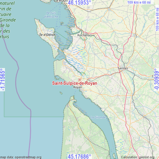
Saint-Sulpice-de-Royan GPS coordinates[2]
45° 40' 13.26" North, 1° 0' 45.072" West
| Map corner | latitude | longitude |
|---|---|---|
| Upper-left | 46.15953°, | -1.71565° |
| Center: | 45.67035°, | -1.01252° |
| Lower-right: | 45.17686°, | -0.30939° |
| Map W x H: | 109.3×109.3 km | = 67.9×67.9mi |
| max Lat: | 51.07786° ⇑71.4% North |
| Saint-Sulpice-de-Royan: | 45.67035° |
| min Lat: | ⇓28.6% South 41.3874° |
| min Long | Saint-Sulpice-d | max Long |
| -5.08615° | -1.01252° | 9.52242° |
| W 11.7%⇐ | ⇒88.3% E |
Elevation
Elevation of Saint-Sulpice-de-Royan is 17 m = 56 ft, and this is 176.7 m = 580 ft below average elevation for this country.
| Max E: |
2333 m = 7654 ft | 95% |
| Avg. | 193.7 m = 635 ft | |
| Saint-Sulpice-de-Royan | 17 m = 56 ft | |
Min E: |
-1 m = -3 ft | 5% |
See also: France elevation on elevation.city.
Geographical zone
Saint-Sulpice-de-Royan is located in North temperate zone (between Tropic of Cancer and the Arctic Circle). Distance of this North polar circle is 2323.1 km =1443.5 mi to North.| Distance of | km | miles | from Saint-Sulpice-de-Royan |
|---|---|---|---|
| North Pole | 4929 | 3062.7 | to North |
| Arctic Circle | 2323.1 | 1443.5 | to North |
| Tropic Cancer | 2472.1 | 1536.1 | to South |
| Equator | 5078.1 | 3155.4 | to South |


Nearby cities:
15 places around Saint-Sulpice-de-Royan: (largest is in red/bold)
• Breuillet
3.8 km =2.4 mi,  307°
307°
• Chaillevette
7.5 km =4.7 mi,  332°
332°
• Le Chay
9.7 km =6 mi,  111°
111°
• Le Gua
8.1 km =5 mi,  40°
40°
• Mornac-sur-Seudre
4.5 km =2.8 mi,  344°
344°
• Médis
4.9 km =3 mi,  127°
127°
• Nieulle-sur-Seudre
8.9 km =5.5 mi,  6°
6°
• Royan
4.8 km =3 mi,  194°
194°
• Sablonceaux
10.6 km =6.6 mi,  65°
65°
• Saint-Augustin
7.7 km =4.8 mi,  281°
281°
• Saint-Georges-de-Didonne
7.5 km =4.7 mi,  175°
175°
• Saint-Palais-sur-Mer
6.6 km =4.1 mi,  242°
242°
• Saujon
6.7 km =4.2 mi,  87°
87°
• Vaux-sur-Mer
4.5 km =2.8 mi,  232°
232°
• Étaules
9.8 km =6.1 mi,  316°
316°
Sources, notices
• [Note1] Compared only with cities in France existing in our database
• [Src1] Map data: © OpenStreetMap contributors (CC-BY-SA)
• [Src2] Other city data from geonames.org with taken over terms of usage.
• [Src3] Geographical zone / Annual Mean Temperature by Robert A. Rohde @ Wikipedia
