Donchery geodata
Donchery (Grand Est) is a populated place; located in France in Europe/Paris (GMT+2) time zone. With population of 2,369 people, there are 4082 cities with bigger population in this country. Compared to other cities in France, 91.5% of cities are located further ↓South; 76.1% of cities are located further ←West and 55.3% of cities have lower elevation than Donchery. Note1
Administrative division(s):
- Level 1: Grand Est
- Level 2: Ardennes
- Level 3: Arrondissement de Sedan
- Level 4: Donchery


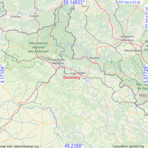
Donchery GPS coordinates[2]
49° 41' 45.024" North, 4° 52' 27.012" East
| Map corner | latitude | longitude |
|---|---|---|
| Upper-left | 50.14853°, | 4.17104° |
| Center: | 49.69584°, | 4.87417° |
| Lower-right: | 49.2389°, | 5.57729° |
| Map W x H: | 101.1×101.1 km | = 62.8×62.8mi |
| max Lat: | 51.07786° ⇑8.5% North |
| Donchery: | 49.69584° |
| min Lat: | ⇓91.5% South 41.3874° |
| min Long | Donchery | max Long |
| -5.08615° | 4.87417° | 9.52242° |
| W 76.1%⇐ | ⇒23.9% E |
Elevation
Elevation of Donchery is 151 m = 495 ft, and this is 42.7 m = 140 ft below average elevation for this country.
| Max E: |
2333 m = 7654 ft | 44.7% |
| Avg. | 193.7 m = 635 ft | |
| Donchery | 151 m = 495 ft | |
Min E: |
-1 m = -3 ft | 55.3% |
See also: France elevation on elevation.city.
Geographical zone
Donchery is located in North temperate zone (between Tropic of Cancer and the Arctic Circle). Distance of this North polar circle is 1875.5 km =1165.4 mi to North.| Distance of | km | miles | from Donchery |
|---|---|---|---|
| North Pole | 4481.4 | 2784.6 | to North |
| Arctic Circle | 1875.5 | 1165.4 | to North |
| Tropic Cancer | 2919.7 | 1814.2 | to South |
| Equator | 5525.7 | 3433.5 | to South |


Nearby cities:
15 places around Donchery: (largest is in red/bold)
• Balan
6.6 km =4.1 mi,  96°
96°
• Bazeilles
7.7 km =4.8 mi,  106°
106°
• Dom-le-Mesnil
5.1 km =3.2 mi,  262°
262°
• Flize
7.4 km =4.6 mi,  272°
272°
• Floing
4.9 km =3 mi,  53°
53°
• Glaire
3.8 km =2.4 mi, 52°
• Lumes
7.7 km =4.8 mi,  304°
304°
• Nouvion-sur-Meuse
5.7 km =3.5 mi, 274°
• Noyers-Pont-Maugis
5.9 km =3.7 mi,  129°
129°
• Saint-Menges
6.1 km =3.8 mi,  38°
38°
• Sapogne-et-Feuchères
6.9 km =4.3 mi,  234°
234°
• Sedan
4.8 km =3 mi,  81°
81°
• Vivier-au-Court
5.3 km =3.3 mi,  322°
322°
• Vrigne-aux-Bois
4.8 km =3 mi,  343°
343°
• Wadelincourt
4.9 km =3 mi, 103°
Sources, notices
• [Note1] Compared only with cities in France existing in our database
• [Src1] Map data: © OpenStreetMap contributors (CC-BY-SA)
• [Src2] Other city data from geonames.org with taken over terms of usage.
• [Src3] Geographical zone / Annual Mean Temperature by Robert A. Rohde @ Wikipedia
