Floing geodata
Floing (Grand Est) is a populated place; located in France in Europe/Paris (GMT+2) time zone. With population of 2,462 people, there are 3941 cities with bigger population in this country. Compared to other cities in France, 91.7% of cities are located further ↓South; 76.8% of cities are located further ←West and 57.4% of cities have lower elevation than Floing. Note1
Administrative division(s):
- Level 1: Grand Est
- Level 2: Ardennes
- Level 3: Arrondissement de Sedan
- Level 4: Floing


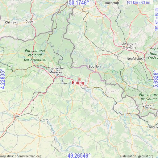
Floing GPS coordinates[2]
49° 43' 19.776" North, 4° 55' 46.092" East
| Map corner | latitude | longitude |
|---|---|---|
| Upper-left | 50.1746°, | 4.22635° |
| Center: | 49.72216°, | 4.92947° |
| Lower-right: | 49.26546°, | 5.6326° |
| Map W x H: | 101.1×101.1 km | = 62.8×62.8mi |
| max Lat: | 51.07786° ⇑8.3% North |
| Floing: | 49.72216° |
| min Lat: | ⇓91.7% South 41.3874° |
| min Long | Floing | max Long |
| -5.08615° | 4.92947° | 9.52242° |
| W 76.8%⇐ | ⇒23.2% E |
Elevation
Elevation of Floing is 159 m = 522 ft, and this is 34.7 m = 114 ft below average elevation for this country.
| Max E: |
2333 m = 7654 ft | 42.6% |
| Avg. | 193.7 m = 635 ft | |
| Floing | 159 m = 522 ft | |
Min E: |
-1 m = -3 ft | 57.4% |
See also: France elevation on elevation.city.
Geographical zone
Floing is located in North temperate zone (between Tropic of Cancer and the Arctic Circle). Distance of this North polar circle is 1872.6 km =1163.6 mi to North.| Distance of | km | miles | from Floing |
|---|---|---|---|
| North Pole | 4478.5 | 2782.8 | to North |
| Arctic Circle | 1872.6 | 1163.6 | to North |
| Tropic Cancer | 2922.7 | 1816.1 | to South |
| Equator | 5528.6 | 3435.3 | to South |


Nearby cities:
15 places around Floing: (largest is in red/bold)
• Balan
4.5 km =2.8 mi,  145°
145°
• Bazeilles
6.1 km =3.8 mi, 145°
• Dom-le-Mesnil
9.7 km =6 mi,  248°
248°
• Donchery
4.9 km =3 mi,  233°
233°
• Douzy
9.9 km =6.2 mi,  125°
125°
• Francheval
8.9 km =5.5 mi,  105°
105°
• Givonne
4.2 km =2.6 mi,  91°
91°
• Glaire
1.1 km =0.7 mi,  236°
236°
• Noyers-Pont-Maugis
6.8 km =4.2 mi,  175°
175°
• Remilly-Aillicourt
9.1 km =5.7 mi, 149°
• Saint-Menges
1.9 km =1.2 mi,  352°
352°
• Sedan
2.4 km =1.5 mi,  160°
160°
• Vivier-au-Court
7.3 km =4.5 mi,  279°
279°
• Vrigne-aux-Bois
5.6 km =3.5 mi,  287°
287°
• Wadelincourt
4.2 km =2.6 mi,  169°
169°
Sources, notices
• [Note1] Compared only with cities in France existing in our database
• [Src1] Map data: © OpenStreetMap contributors (CC-BY-SA)
• [Src2] Other city data from geonames.org with taken over terms of usage.
• [Src3] Geographical zone / Annual Mean Temperature by Robert A. Rohde @ Wikipedia
