Coutras geodata
Coutras (Nouvelle-Aquitaine) is a populated place; located in France in Europe/Paris (GMT+2) time zone. With population of 7,682 people, there are 1260 cities with bigger population in this country. Compared to other cities in France, 79.3% of cities are located further ↑North; 79.1% of cities are located further →East and 96.3% of cities have higher elevation than Coutras. Note1
Administrative division(s):
- Level 1: Nouvelle-Aquitaine
- Level 2: Gironde
- Level 3: Arrondissement de Libourne
- Level 4: Coutras


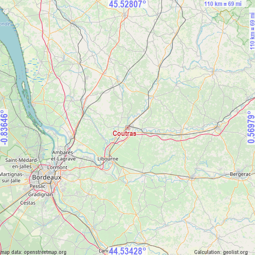
Coutras GPS coordinates[2]
45° 1' 59.988" North, 0° 7' 59.988" West
| Map corner | latitude | longitude |
|---|---|---|
| Upper-left | 45.52807°, | -0.83646° |
| Center: | 45.03333°, | -0.13333° |
| Lower-right: | 44.53428°, | 0.56979° |
| Map W x H: | 110.5×110.5 km | = 68.7×68.7mi |
| max Lat: | 51.07786° ⇑79.3% North |
| Coutras: | 45.03333° |
| min Lat: | ⇓20.7% South 41.3874° |
| min Long | Coutras | max Long |
| -5.08615° | -0.13333° | 9.52242° |
| W 20.9%⇐ | ⇒79.1% E |
Elevation
Elevation of Coutras is 13 m = 43 ft, and this is 180.7 m = 593 ft below average elevation for this country.
| Max E: |
2333 m = 7654 ft | 96.3% |
| Avg. | 193.7 m = 635 ft | |
| Coutras | 13 m = 43 ft | |
Min E: |
-1 m = -3 ft | 3.7% |
See also: France elevation on elevation.city.
Geographical zone
Coutras is located in North temperate zone (between Tropic of Cancer and the Arctic Circle). Distance of this North polar circle is 2393.9 km =1487.5 mi to North.| Distance of | km | miles | from Coutras |
|---|---|---|---|
| North Pole | 4999.8 | 3106.7 | to North |
| Arctic Circle | 2393.9 | 1487.5 | to North |
| Tropic Cancer | 2401.3 | 1492.1 | to South |
| Equator | 5007.2 | 3111.3 | to South |


Nearby cities:
15 places around Coutras: (largest is in red/bold)
• Abzac
1.9 km =1.2 mi,  180°
180°
• Bonzac
7.5 km =4.7 mi,  240°
240°
• Chamadelle
9.1 km =5.7 mi,  35°
35°
• Guîtres
3.9 km =2.4 mi,  270°
270°
• La Clotte
9.4 km =5.8 mi,  351°
351°
• Lagorce
3.7 km =2.3 mi,  0°
0°
• Les Artigues-de-Lussac
7.5 km =4.7 mi,  190°
190°
• Les Peintures
4.5 km =2.8 mi, 35°
• Les Églisottes-et-Chalaures
10.3 km =6.4 mi,  45°
45°
• Lussac
9.6 km =6 mi,  164°
164°
• Petit-Palais-et-Cornemps
7.6 km =4.7 mi,  136°
136°
• Sablons
3.9 km =2.4 mi, 270°
• Saint-Denis-de-Pile
6.4 km =4 mi,  234°
234°
• Saint-Médard-de-Guizières
6.8 km =4.2 mi,  105°
105°
• Savignac-de-l'Isle
9.6 km =6 mi, 234°
Sources, notices
• [Note1] Compared only with cities in France existing in our database
• [Src1] Map data: © OpenStreetMap contributors (CC-BY-SA)
• [Src2] Other city data from geonames.org with taken over terms of usage.
• [Src3] Geographical zone / Annual Mean Temperature by Robert A. Rohde @ Wikipedia
