Chamadelle geodata
Chamadelle (Nouvelle-Aquitaine) is a populated place; located in France in Europe/Paris (GMT+2) time zone. With population of 610 people, there are 13160 cities with bigger population in this country. Compared to other cities in France, 78.6% of cities are located further ↑North; 78.6% of cities are located further →East and 93.1% of cities have higher elevation than Chamadelle. Note1
Administrative division(s):
- Level 1: Nouvelle-Aquitaine
- Level 2: Gironde
- Level 3: Arrondissement de Libourne
- Level 4: Chamadelle


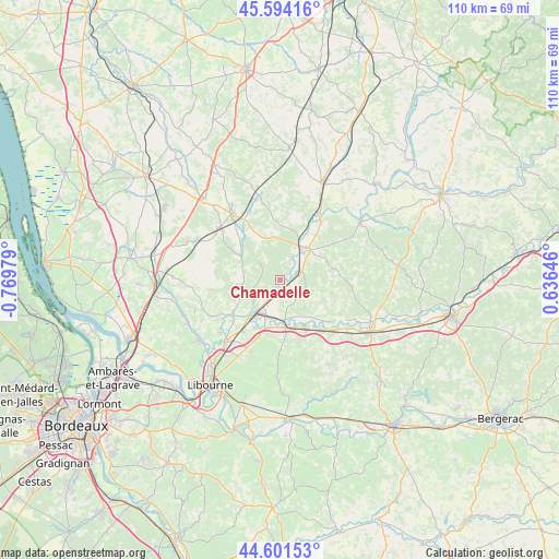
Chamadelle GPS coordinates[2]
45° 6' 0" North, 0° 4' 0.012" West
| Map corner | latitude | longitude |
|---|---|---|
| Upper-left | 45.59416°, | -0.76979° |
| Center: | 45.1°, | -0.06667° |
| Lower-right: | 44.60153°, | 0.63646° |
| Map W x H: | 110.4×110.4 km | = 68.6×68.6mi |
| max Lat: | 51.07786° ⇑78.6% North |
| Chamadelle: | 45.1° |
| min Lat: | ⇓21.4% South 41.3874° |
| min Long | Chamadelle | max Long |
| -5.08615° | -0.06667° | 9.52242° |
| W 21.4%⇐ | ⇒78.6% E |
Elevation
Elevation of Chamadelle is 22 m = 72 ft, and this is 171.7 m = 563 ft below average elevation for this country.
| Max E: |
2333 m = 7654 ft | 93.1% |
| Avg. | 193.7 m = 635 ft | |
| Chamadelle | 22 m = 72 ft | |
Min E: |
-1 m = -3 ft | 6.9% |
See also: France elevation on elevation.city.
Geographical zone
Chamadelle is located in North temperate zone (between Tropic of Cancer and the Arctic Circle). Distance of this North polar circle is 2386.5 km =1482.9 mi to North.| Distance of | km | miles | from Chamadelle |
|---|---|---|---|
| North Pole | 4992.4 | 3102.1 | to North |
| Arctic Circle | 2386.5 | 1482.9 | to North |
| Tropic Cancer | 2408.7 | 1496.7 | to South |
| Equator | 5014.6 | 3115.9 | to South |


Nearby cities:
15 places around Chamadelle: (largest is in red/bold)
• Abzac
10.6 km =6.6 mi,  209°
209°
• Cercoux
11.1 km =6.9 mi,  289°
289°
• Coutras
9.1 km =5.7 mi,  215°
215°
• Guîtres
11.8 km =7.3 mi,  231°
231°
• La Clotte
6.8 km =4.2 mi, 285°
• La Roche-Chalais
8.6 km =5.3 mi,  49°
49°
• Lagorce
6.4 km =4 mi, 234°
• Le Fouilloux
10.1 km =6.3 mi,  337°
337°
• Les Peintures
4.5 km =2.8 mi, 215°
• Les Églisottes-et-Chalaures
2.2 km =1.4 mi,  95°
95°
• Porchères
9.9 km =6.2 mi,  138°
138°
• Sablons
11.8 km =7.3 mi, 231°
• Saint-Aigulin
7.8 km =4.8 mi,  35°
35°
• Saint-Médard-de-Guizières
9.4 km =5.8 mi,  171°
171°
• Saint-Seurin-sur-l’Isle
10.6 km =6.6 mi,  150°
150°
Sources, notices
• [Note1] Compared only with cities in France existing in our database
• [Src1] Map data: © OpenStreetMap contributors (CC-BY-SA)
• [Src2] Other city data from geonames.org with taken over terms of usage.
• [Src3] Geographical zone / Annual Mean Temperature by Robert A. Rohde @ Wikipedia
