Clénay geodata
Clénay (Bourgogne-Franche-Comté) is a populated place; located in France in Europe/Paris (GMT+2) time zone. With population of 592 people, there are 13451 cities with bigger population in this country. Compared to other cities in France, 50% of cities are located further ↓South; 78.9% of cities are located further ←West and 74.6% of cities have lower elevation than Clénay. Note1
Administrative division(s):
- Level 1: Bourgogne-Franche-Comté
- Level 2: Département de la Côte-d'Or
- Level 3: Arrondissement de Dijon
- Level 4: Clénay


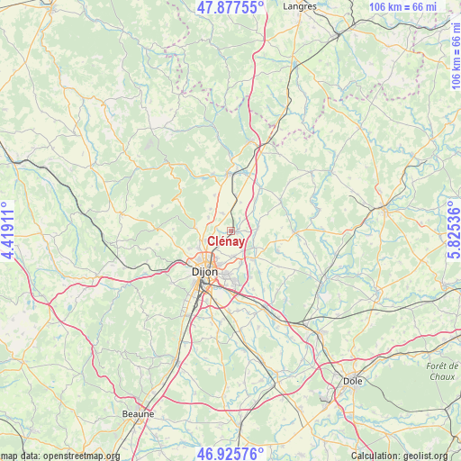
Clénay GPS coordinates[2]
47° 24' 13.68" North, 5° 7' 20.028" East
| Map corner | latitude | longitude |
|---|---|---|
| Upper-left | 47.87755°, | 4.41911° |
| Center: | 47.4038°, | 5.12223° |
| Lower-right: | 46.92576°, | 5.82536° |
| Map W x H: | 105.8×105.8 km | = 65.7×65.7mi |
| max Lat: | 51.07786° ⇑50% North |
| Clénay: | 47.4038° |
| min Lat: | ⇓50% South 41.3874° |
| min Long | Clénay | max Long |
| -5.08615° | 5.12223° | 9.52242° |
| W 78.9%⇐ | ⇒21.1% E |
Elevation
Elevation of Clénay is 246 m = 807 ft, and this is 52.3 m = 172 ft above average elevation for this country.
| Max E: |
2333 m = 7654 ft | 25.4% |
| Clénay | 246 m 807 ft | |
| Avg. | 193.7 m = 635 ft | |
Min E: |
-1 m = -3 ft | 74.6% |
See also: France elevation on elevation.city.
Geographical zone
Clénay is located in North temperate zone (between Tropic of Cancer and the Arctic Circle). Distance of this North polar circle is 2130.4 km =1323.8 mi to North.| Distance of | km | miles | from Clénay |
|---|---|---|---|
| North Pole | 4736.3 | 2943 | to North |
| Arctic Circle | 2130.4 | 1323.8 | to North |
| Tropic Cancer | 2664.9 | 1655.9 | to South |
| Equator | 5270.8 | 3275.1 | to South |


Nearby cities:
15 places around Clénay: (largest is in red/bold)
• Arc-sur-Tille
8.3 km =5.2 mi,  144°
144°
• Arceau
5.5 km =3.4 mi,  112°
112°
• Asnières-lès-Dijon
7.1 km =4.4 mi,  251°
251°
• Beire-le-Châtel
6.3 km =3.9 mi,  80°
80°
• Bellefond
4.9 km =3 mi,  236°
236°
• Bretigny
1.7 km =1.1 mi,  255°
255°
• Couternon
8.1 km =5 mi,  165°
165°
• Gemeaux
8.3 km =5.2 mi,  7°
7°
• Marsannay-le-Bois
4.5 km =2.8 mi,  333°
333°
• Messigny-et-Vantoux
7.9 km =4.9 mi,  272°
272°
• Norges-la-Ville
3.4 km =2.1 mi,  276°
276°
• Ruffey-lès-Echirey
5.1 km =3.2 mi,  215°
215°
• Saint-Julien
1.5 km =0.9 mi,  104°
104°
• Savigny-le-Sec
6.1 km =3.8 mi,  301°
301°
• Varois-et-Chaignot
5.9 km =3.7 mi,  175°
175°
Sources, notices
• [Note1] Compared only with cities in France existing in our database
• [Src1] Map data: © OpenStreetMap contributors (CC-BY-SA)
• [Src2] Other city data from geonames.org with taken over terms of usage.
• [Src3] Geographical zone / Annual Mean Temperature by Robert A. Rohde @ Wikipedia
