Bellefond geodata
Bellefond (Bourgogne-Franche-Comté) is a populated place; located in France in Europe/Paris (GMT+2) time zone. With population of 751 people, there are 11157 cities with bigger population in this country. Compared to other cities in France, 50.4% of cities are located further ↑North; 78.4% of cities are located further ←West and 80.4% of cities have lower elevation than Bellefond. Note1
Administrative division(s):
- Level 1: Bourgogne-Franche-Comté
- Level 2: Département de la Côte-d'Or
- Level 3: Arrondissement de Dijon
- Level 4: Bellefond


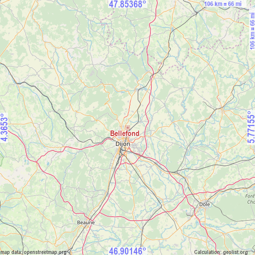
Bellefond GPS coordinates[2]
47° 22' 46.992" North, 5° 4' 6.312" East
| Map corner | latitude | longitude |
|---|---|---|
| Upper-left | 47.85368°, | 4.3653° |
| Center: | 47.37972°, | 5.06842° |
| Lower-right: | 46.90146°, | 5.77155° |
| Map W x H: | 105.9×105.9 km | = 65.8×65.8mi |
| max Lat: | 51.07786° ⇑50.4% North |
| Bellefond: | 47.37972° |
| min Lat: | ⇓49.6% South 41.3874° |
| min Long | Bellefond | max Long |
| -5.08615° | 5.06842° | 9.52242° |
| W 78.4%⇐ | ⇒21.6% E |
Elevation
Elevation of Bellefond is 295 m = 968 ft, and this is 101.3 m = 332 ft above average elevation for this country.
| Max E: |
2333 m = 7654 ft | 19.6% |
| Bellefond | 295 m 968 ft | |
| Avg. | 193.7 m = 635 ft | |
Min E: |
-1 m = -3 ft | 80.4% |
See also: France elevation on elevation.city.
Geographical zone
Bellefond is located in North temperate zone (between Tropic of Cancer and the Arctic Circle). Distance of this North polar circle is 2133 km =1325.4 mi to North.| Distance of | km | miles | from Bellefond |
|---|---|---|---|
| North Pole | 4738.9 | 2944.6 | to North |
| Arctic Circle | 2133 | 1325.4 | to North |
| Tropic Cancer | 2662.2 | 1654.2 | to South |
| Equator | 5268.1 | 3273.4 | to South |


Nearby cities:
15 places around Bellefond: (largest is in red/bold)
• Ahuy
3.8 km =2.4 mi,  252°
252°
• Asnières-lès-Dijon
2.7 km =1.7 mi,  278°
278°
• Bretigny
3.3 km =2.1 mi,  46°
46°
• Clénay
4.9 km =3 mi,  56°
56°
• Daix
6 km =3.7 mi,  237°
237°
• Fontaine-lès-Dijon
5.5 km =3.4 mi,  221°
221°
• Hauteville-lès-Dijon
5.8 km =3.6 mi, 254°
• Messigny-et-Vantoux
4.9 km =3 mi,  307°
307°
• Norges-la-Ville
3.2 km =2 mi,  12°
12°
• Ruffey-lès-Echirey
1.8 km =1.1 mi,  142°
142°
• Saint-Apollinaire
5.3 km =3.3 mi,  167°
167°
• Saint-Julien
6 km =3.7 mi,  67°
67°
• Savigny-le-Sec
5.9 km =3.7 mi,  348°
348°
• Talant
6.5 km =4 mi, 223°
• Varois-et-Chaignot
5.6 km =3.5 mi,  125°
125°
Sources, notices
• [Note1] Compared only with cities in France existing in our database
• [Src1] Map data: © OpenStreetMap contributors (CC-BY-SA)
• [Src2] Other city data from geonames.org with taken over terms of usage.
• [Src3] Geographical zone / Annual Mean Temperature by Robert A. Rohde @ Wikipedia
