Chirens geodata
Chirens (Auvergne-Rhône-Alpes) is a populated place; located in France in Europe/Paris (GMT+2) time zone. With population of 2,057 people, there are 4667 cities with bigger population in this country. Compared to other cities in France, 75.1% of cities are located further ↑North; 83.4% of cities are located further ←West and 92.5% of cities have lower elevation than Chirens. Note1
Administrative division(s):
- Level 1: Auvergne-Rhône-Alpes
- Level 2: Département de l'Isère
- Level 3: Arrondissement de Grenoble
- Level 4: Chirens


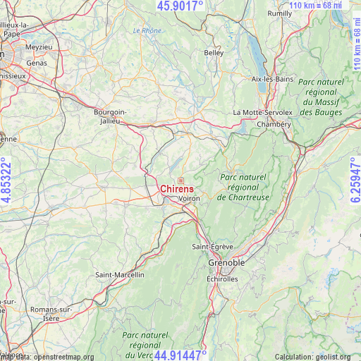
Chirens GPS coordinates[2]
45° 24' 36.864" North, 5° 33' 22.824" East
| Map corner | latitude | longitude |
|---|---|---|
| Upper-left | 45.9017°, | 4.85322° |
| Center: | 45.41024°, | 5.55634° |
| Lower-right: | 44.91447°, | 6.25947° |
| Map W x H: | 109.8×109.8 km | = 68.2×68.2mi |
| max Lat: | 51.07786° ⇑75.1% North |
| Chirens: | 45.41024° |
| min Lat: | ⇓24.9% South 41.3874° |
| min Long | Chirens | max Long |
| -5.08615° | 5.55634° | 9.52242° |
| W 83.4%⇐ | ⇒16.6% E |
Elevation
Elevation of Chirens is 489 m = 1604 ft, and this is 295.3 m = 969 ft above average elevation for this country.
| Max E: |
2333 m = 7654 ft | 7.5% |
| Chirens | 489 m 1604 ft | |
| Avg. | 193.7 m = 635 ft | |
Min E: |
-1 m = -3 ft | 92.5% |
See also: France elevation on elevation.city.
Geographical zone
Chirens is located in North temperate zone (between Tropic of Cancer and the Arctic Circle). Distance of this North polar circle is 2352 km =1461.5 mi to North.| Distance of | km | miles | from Chirens |
|---|---|---|---|
| North Pole | 4957.9 | 3080.7 | to North |
| Arctic Circle | 2352 | 1461.5 | to North |
| Tropic Cancer | 2443.2 | 1518.1 | to South |
| Equator | 5049.1 | 3137.4 | to South |


Nearby cities:
15 places around Chirens: (largest is in red/bold)
• Apprieu
4.7 km =2.9 mi,  250°
250°
• Bilieu
4.3 km =2.7 mi,  345°
345°
• Charavines
3.8 km =2.4 mi,  302°
302°
• Coublevie
7.2 km =4.5 mi,  143°
143°
• La Murette
3.7 km =2.3 mi,  197°
197°
• Le Pin
6.5 km =4 mi,  321°
321°
• Massieu
4.6 km =2.9 mi,  44°
44°
• Oyeu
6.5 km =4 mi,  281°
281°
• Paladru
7.3 km =4.5 mi,  359°
359°
• Réaumont
5.6 km =3.5 mi,  207°
207°
• Saint-Blaise-du-Buis
4.7 km =2.9 mi,  219°
219°
• Saint-Cassien
5.9 km =3.7 mi,  186°
186°
• Saint-Nicolas-de-Macherin
3.7 km =2.3 mi,  102°
102°
• Saint-Étienne-de-Crossey
7.6 km =4.7 mi,  116°
116°
• Voiron
5.6 km =3.5 mi,  155°
155°
Sources, notices
• [Note1] Compared only with cities in France existing in our database
• [Src1] Map data: © OpenStreetMap contributors (CC-BY-SA)
• [Src2] Other city data from geonames.org with taken over terms of usage.
• [Src3] Geographical zone / Annual Mean Temperature by Robert A. Rohde @ Wikipedia
