Chépy geodata
Chépy (Hauts-de-France) is a populated place; located in France in Europe/Paris (GMT+2) time zone. With population of 1,319 people, there are 6944 cities with bigger population in this country. Compared to other cities in France, 93.9% of cities are located further ↓South; 61.1% of cities are located further →East and 62.8% of cities have higher elevation than Chépy. Note1
Administrative division(s):
- Level 1: Hauts-de-France
- Level 2: Somme
- Level 3: Abbeville
- Level 4: Chépy


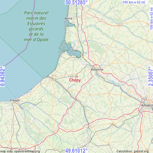
Chépy GPS coordinates[2]
50° 3' 48.996" North, 1° 38' 48.984" East
| Map corner | latitude | longitude |
|---|---|---|
| Upper-left | 50.51285°, | 0.94382° |
| Center: | 50.06361°, | 1.64694° |
| Lower-right: | 49.61012°, | 2.35007° |
| Map W x H: | 100.4×100.4 km | = 62.4×62.4mi |
| max Lat: | 51.07786° ⇑6.1% North |
| Chépy: | 50.06361° |
| min Lat: | ⇓93.9% South 41.3874° |
| min Long | Chépy | max Long |
| -5.08615° | 1.64694° | 9.52242° |
| W 38.9%⇐ | ⇒61.1% E |
Elevation
Elevation of Chépy is 95 m = 312 ft, and this is 98.7 m = 324 ft below average elevation for this country.
| Max E: |
2333 m = 7654 ft | 62.8% |
| Avg. | 193.7 m = 635 ft | |
| Chépy | 95 m = 312 ft | |
Min E: |
-1 m = -3 ft | 37.2% |
See also: France elevation on elevation.city.
Geographical zone
Chépy is located in North temperate zone (between Tropic of Cancer and the Arctic Circle). Distance of this North polar circle is 1834.6 km =1140 mi to North.| Distance of | km | miles | from Chépy |
|---|---|---|---|
| North Pole | 4440.5 | 2759.2 | to North |
| Arctic Circle | 1834.6 | 1140 | to North |
| Tropic Cancer | 2960.6 | 1839.6 | to South |
| Equator | 5566.6 | 3458.9 | to South |


Nearby cities:
15 places around Chépy: (largest is in red/bold)
• Acheux-en-Vimeu
2.1 km =1.3 mi,  85°
85°
• Aigneville
3.7 km =2.3 mi,  210°
210°
• Arrest
7.8 km =4.8 mi,  343°
343°
• Feuquières-en-Vimeu
3 km =1.9 mi,  262°
262°
• Franleu
3.9 km =2.4 mi,  353°
353°
• Fressenneville
4.9 km =3 mi,  276°
276°
• Friville-Escarbotin
7.6 km =4.7 mi,  289°
289°
• Maisnières
5.8 km =3.6 mi,  201°
201°
• Miannay
6.3 km =3.9 mi,  54°
54°
• Moyenneville
7.4 km =4.6 mi,  83°
83°
• Nibas
6 km =3.7 mi,  316°
316°
• Quesnoy-le-Montant
6 km =3.7 mi,  30°
30°
• Tours-en-Vimeu
4.1 km =2.5 mi,  140°
140°
• Valines
2.2 km =1.4 mi,  309°
309°
• Woincourt
7.9 km =4.9 mi,  272°
272°
Sources, notices
• [Note1] Compared only with cities in France existing in our database
• [Src1] Map data: © OpenStreetMap contributors (CC-BY-SA)
• [Src2] Other city data from geonames.org with taken over terms of usage.
• [Src3] Geographical zone / Annual Mean Temperature by Robert A. Rohde @ Wikipedia
