Aigneville geodata
Aigneville (Hauts-de-France) is a populated place; located in France in Europe/Paris (GMT+2) time zone. With population of 675 people, there are 12136 cities with bigger population in this country. Compared to other cities in France, 93.8% of cities are located further ↓South; 61.4% of cities are located further →East and 55.2% of cities have higher elevation than Aigneville. Note1
Administrative division(s):
- Level 1: Hauts-de-France
- Level 2: Somme
- Level 3: Abbeville
- Level 4: Aigneville


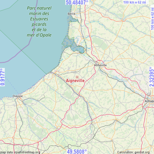
Aigneville GPS coordinates[2]
50° 2' 4.416" North, 1° 37' 14.952" East
| Map corner | latitude | longitude |
|---|---|---|
| Upper-left | 50.48407°, | 0.9177° |
| Center: | 50.03456°, | 1.62082° |
| Lower-right: | 49.5808°, | 2.32395° |
| Map W x H: | 100.4×100.4 km | = 62.4×62.4mi |
| max Lat: | 51.07786° ⇑6.2% North |
| Aigneville: | 50.03456° |
| min Lat: | ⇓93.8% South 41.3874° |
| min Long | Aigneville | max Long |
| -5.08615° | 1.62082° | 9.52242° |
| W 38.6%⇐ | ⇒61.4% E |
Elevation
Elevation of Aigneville is 116 m = 381 ft, and this is 77.7 m = 255 ft below average elevation for this country.
| Max E: |
2333 m = 7654 ft | 55.2% |
| Avg. | 193.7 m = 635 ft | |
| Aigneville | 116 m = 381 ft | |
Min E: |
-1 m = -3 ft | 44.8% |
See also: France elevation on elevation.city.
Geographical zone
Aigneville is located in North temperate zone (between Tropic of Cancer and the Arctic Circle). Distance of this North polar circle is 1837.9 km =1142 mi to North.| Distance of | km | miles | from Aigneville |
|---|---|---|---|
| North Pole | 4443.7 | 2761.2 | to North |
| Arctic Circle | 1837.9 | 1142 | to North |
| Tropic Cancer | 2957.4 | 1837.6 | to South |
| Equator | 5563.3 | 3456.9 | to South |


Nearby cities:
15 places around Aigneville: (largest is in red/bold)
• Acheux-en-Vimeu
5.2 km =3.2 mi,  49°
49°
• Beauchamps
7.8 km =4.8 mi,  251°
251°
• Chépy
3.7 km =2.3 mi,  30°
30°
• Dargnies
6.9 km =4.3 mi,  276°
276°
• Embreville
5.7 km =3.5 mi,  263°
263°
• Feuquières-en-Vimeu
3 km =1.9 mi,  337°
337°
• Franleu
7.3 km =4.5 mi,  11°
11°
• Fressenneville
4.8 km =3 mi,  320°
320°
• Gamaches
7.1 km =4.4 mi,  220°
220°
• Longroy
7.7 km =4.8 mi,  228°
228°
• Maisnières
2.2 km =1.4 mi,  186°
186°
• Tours-en-Vimeu
4.5 km =2.8 mi,  89°
89°
• Valines
4.7 km =2.9 mi,  1°
1°
• Woincourt
7 km =4.3 mi,  300°
300°
• Yzengremer
7.6 km =4.7 mi,  292°
292°
Sources, notices
• [Note1] Compared only with cities in France existing in our database
• [Src1] Map data: © OpenStreetMap contributors (CC-BY-SA)
• [Src2] Other city data from geonames.org with taken over terms of usage.
• [Src3] Geographical zone / Annual Mean Temperature by Robert A. Rohde @ Wikipedia
