Chavanod geodata
Chavanod (Auvergne-Rhône-Alpes) is a populated place; located in France in Europe/Paris (GMT+2) time zone. With population of 2,226 people, there are 4313 cities with bigger population in this country. Compared to other cities in France, 67.8% of cities are located further ↑North; 87.5% of cities are located further ←West and 93.2% of cities have lower elevation than Chavanod. Note1
Administrative division(s):
- Level 1: Auvergne-Rhône-Alpes
- Level 2: Haute-Savoie
- Level 3: Annecy
- Level 4: Chavanod


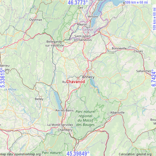
Chavanod GPS coordinates[2]
45° 53' 24.18" North, 6° 2' 21.408" East
| Map corner | latitude | longitude |
|---|---|---|
| Upper-left | 46.3773°, | 5.33615° |
| Center: | 45.89005°, | 6.03928° |
| Lower-right: | 45.39849°, | 6.7424° |
| Map W x H: | 108.8×108.8 km | = 67.6×67.6mi |
| max Lat: | 51.07786° ⇑67.8% North |
| Chavanod: | 45.89005° |
| min Lat: | ⇓32.2% South 41.3874° |
| min Long | Chavanod | max Long |
| -5.08615° | 6.03928° | 9.52242° |
| W 87.5%⇐ | ⇒12.5% E |
Elevation
Elevation of Chavanod is 510 m = 1673 ft, and this is 316.3 m = 1038 ft above average elevation for this country.
| Max E: |
2333 m = 7654 ft | 6.8% |
| Chavanod | 510 m 1673 ft | |
| Avg. | 193.7 m = 635 ft | |
Min E: |
-1 m = -3 ft | 93.2% |
See also: France elevation on elevation.city.
Geographical zone
Chavanod is located in North temperate zone (between Tropic of Cancer and the Arctic Circle). Distance of this North polar circle is 2298.7 km =1428.3 mi to North.| Distance of | km | miles | from Chavanod |
|---|---|---|---|
| North Pole | 4904.6 | 3047.6 | to North |
| Arctic Circle | 2298.7 | 1428.3 | to North |
| Tropic Cancer | 2496.6 | 1551.3 | to South |
| Equator | 5102.5 | 3170.5 | to South |


Nearby cities:
15 places around Chavanod: (largest is in red/bold)
• Chapeiry
4.5 km =2.8 mi,  185°
185°
• Cran-Gevrier
4.8 km =3 mi,  76°
76°
• Hauteville-sur-Fier
5.4 km =3.4 mi,  286°
286°
• Lovagny
1.6 km =1 mi,  341°
341°
• Marcellaz-Albanais
3.5 km =2.2 mi,  242°
242°
• Meythet
5.3 km =3.3 mi,  53°
53°
• Nonglard
3.6 km =2.2 mi, 338°
• Poisy
4 km =2.5 mi,  28°
28°
• Quintal
6.3 km =3.9 mi,  146°
146°
• Saint-Sylvestre
6.1 km =3.8 mi, 194°
• Seynod
3.8 km =2.4 mi,  97°
97°
• Sillingy
6.4 km =4 mi,  3°
3°
• Vaulx
5.6 km =3.5 mi,  322°
322°
• Épagny
6.1 km =3.8 mi, 33°
• Étercy
2.6 km =1.6 mi,  276°
276°
Sources, notices
• [Note1] Compared only with cities in France existing in our database
• [Src1] Map data: © OpenStreetMap contributors (CC-BY-SA)
• [Src2] Other city data from geonames.org with taken over terms of usage.
• [Src3] Geographical zone / Annual Mean Temperature by Robert A. Rohde @ Wikipedia
