Chapeiry geodata
Chapeiry (Auvergne-Rhône-Alpes) is a populated place; located in France in Europe/Paris (GMT+2) time zone. With population of 665 people, there are 12292 cities with bigger population in this country. Compared to other cities in France, 68.5% of cities are located further ↑North; 87.4% of cities are located further ←West and 95.5% of cities have lower elevation than Chapeiry. Note1
Administrative division(s):
- Level 1: Auvergne-Rhône-Alpes
- Level 2: Haute-Savoie
- Level 3: Annecy
- Level 4: Chapeiry


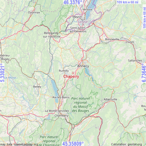
Chapeiry GPS coordinates[2]
45° 51' 0" North, 6° 1' 59.988" East
| Map corner | latitude | longitude |
|---|---|---|
| Upper-left | 46.3376°, | 5.33021° |
| Center: | 45.85°, | 6.03333° |
| Lower-right: | 45.35809°, | 6.73646° |
| Map W x H: | 108.9×108.9 km | = 67.7×67.7mi |
| max Lat: | 51.07786° ⇑68.5% North |
| Chapeiry: | 45.85° |
| min Lat: | ⇓31.5% South 41.3874° |
| min Long | Chapeiry | max Long |
| -5.08615° | 6.03333° | 9.52242° |
| W 87.4%⇐ | ⇒12.6% E |
Elevation
Elevation of Chapeiry is 613 m = 2011 ft, and this is 419.3 m = 1376 ft above average elevation for this country.
| Max E: |
2333 m = 7654 ft | 4.5% |
| Chapeiry | 613 m 2011 ft | |
| Avg. | 193.7 m = 635 ft | |
Min E: |
-1 m = -3 ft | 95.5% |
See also: France elevation on elevation.city.
Geographical zone
Chapeiry is located in North temperate zone (between Tropic of Cancer and the Arctic Circle). Distance of this North polar circle is 2303.1 km =1431.1 mi to North.| Distance of | km | miles | from Chapeiry |
|---|---|---|---|
| North Pole | 4909 | 3050.3 | to North |
| Arctic Circle | 2303.1 | 1431.1 | to North |
| Tropic Cancer | 2492.1 | 1548.5 | to South |
| Equator | 5098 | 3167.7 | to South |


Nearby cities:
15 places around Chapeiry: (largest is in red/bold)
• Alby-sur-Chéran
3.9 km =2.4 mi,  199°
199°
• Chavanod
4.5 km =2.8 mi,  5°
5°
• Héry-sur-Alby
6.1 km =3.8 mi, 196°
• Lovagny
6 km =3.7 mi,  359°
359°
• Marcellaz-Albanais
3.9 km =2.4 mi,  316°
316°
• Marigny-Saint-Marcel
4.6 km =2.9 mi,  242°
242°
• Mûres
4.9 km =3 mi,  175°
175°
• Quintal
4 km =2.5 mi,  101°
101°
• Rumilly
6.9 km =4.3 mi,  280°
280°
• Saint-Félix
6.8 km =4.2 mi,  219°
219°
• Saint-Sylvestre
1.8 km =1.1 mi, 217°
• Sales
6.3 km =3.9 mi,  295°
295°
• Seynod
5.8 km =3.6 mi,  47°
47°
• Viuz-la-Chiésaz
4.9 km =3 mi,  148°
148°
• Étercy
5.2 km =3.2 mi,  336°
336°
Sources, notices
• [Note1] Compared only with cities in France existing in our database
• [Src1] Map data: © OpenStreetMap contributors (CC-BY-SA)
• [Src2] Other city data from geonames.org with taken over terms of usage.
• [Src3] Geographical zone / Annual Mean Temperature by Robert A. Rohde @ Wikipedia
