Cérences geodata
Cérences (Normandy) is a populated place; located in France in Europe/Paris (GMT+2) time zone. With population of 1,802 people, there are 5270 cities with bigger population in this country. Compared to other cities in France, 77.9% of cities are located further ↓South; 91.8% of cities are located further →East and 80.6% of cities have higher elevation than Cérences. Note1


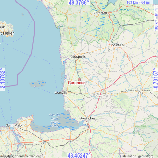
Cérences GPS coordinates[2]
48° 55' 0.012" North, 1° 26' 4.92" West
| Map corner | latitude | longitude |
|---|---|---|
| Upper-left | 49.3766°, | -2.13782° |
| Center: | 48.91667°, | -1.4347° |
| Lower-right: | 48.45247°, | -0.73157° |
| Map W x H: | 102.8×102.8 km | = 63.9×63.9mi |
| max Lat: | 51.07786° ⇑22.1% North |
| Cérences: | 48.91667° |
| min Lat: | ⇓77.9% South 41.3874° |
| min Long | Cérences | max Long |
| -5.08615° | -1.4347° | 9.52242° |
| W 8.2%⇐ | ⇒91.8% E |
Elevation
Elevation of Cérences is 53 m = 174 ft, and this is 140.7 m = 462 ft below average elevation for this country.
| Max E: |
2333 m = 7654 ft | 80.6% |
| Avg. | 193.7 m = 635 ft | |
| Cérences | 53 m = 174 ft | |
Min E: |
-1 m = -3 ft | 19.4% |
See also: France elevation on elevation.city.
Geographical zone
Cérences is located in North temperate zone (between Tropic of Cancer and the Arctic Circle). Distance of this North polar circle is 1962.2 km =1219.3 mi to North.| Distance of | km | miles | from Cérences |
|---|---|---|---|
| North Pole | 4568 | 2838.4 | to North |
| Arctic Circle | 1962.2 | 1219.3 | to North |
| Tropic Cancer | 2833.1 | 1760.4 | to South |
| Equator | 5439 | 3379.6 | to South |


Nearby cities:
15 places around Cérences: (largest is in red/bold)
• Annoville
9.2 km =5.7 mi,  306°
306°
• Bricqueville-sur-Mer
6.3 km =3.9 mi,  266°
266°
• Bréhal
6 km =3.7 mi,  251°
251°
• Coudeville-sur-Mer
7.8 km =4.8 mi,  240°
240°
• Folligny
10.4 km =6.5 mi,  170°
170°
• Gavray
6.2 km =3.9 mi,  95°
95°
• Hauteville-sur-Mer
10.3 km =6.4 mi, 310°
• Hudimesnil
7.3 km =4.5 mi,  215°
215°
• Lingreville
7.8 km =4.8 mi,  299°
299°
• Montmartin-sur-Mer
10.4 km =6.5 mi,  320°
320°
• Quettreville-sur-Sienne
6.2 km =3.9 mi,  337°
337°
• Saint-Denis-le-Vêtu
8.1 km =5 mi,  16°
16°
• Saint-Jean-des-Champs
10.1 km =6.3 mi,  192°
192°
• Saussey
10.3 km =6.4 mi,  0°
0°
• Trelly
4.9 km =3 mi,  6°
6°
Sources, notices
• [Note1] Compared only with cities in France existing in our database
• [Src1] Map data: © OpenStreetMap contributors (CC-BY-SA)
• [Src2] Other city data from geonames.org with taken over terms of usage.
• [Src3] Geographical zone / Annual Mean Temperature by Robert A. Rohde @ Wikipedia
