Lingreville geodata
Lingreville (Normandy) is a populated place; located in France in Europe/Paris (GMT+2) time zone. With population of 945 people, there are 9241 cities with bigger population in this country. Compared to other cities in France, 78.6% of cities are located further ↓South; 92.5% of cities are located further →East and 92.4% of cities have higher elevation than Lingreville. Note1
Administrative division(s):
- Level 1: Normandy
- Level 2: Manche
- Level 3: Arrondissement de Coutances
- Level 4: Lingreville


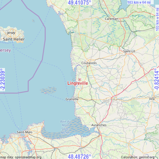
Lingreville GPS coordinates[2]
48° 57' 4.104" North, 1° 31' 38.172" West
| Map corner | latitude | longitude |
|---|---|---|
| Upper-left | 49.41075°, | -2.23039° |
| Center: | 48.95114°, | -1.52727° |
| Lower-right: | 48.48726°, | -0.82414° |
| Map W x H: | 102.7×102.7 km | = 63.8×63.8mi |
| max Lat: | 51.07786° ⇑21.4% North |
| Lingreville: | 48.95114° |
| min Lat: | ⇓78.6% South 41.3874° |
| min Long | Lingreville | max Long |
| -5.08615° | -1.52727° | 9.52242° |
| W 7.5%⇐ | ⇒92.5% E |
Elevation
Elevation of Lingreville is 24 m = 79 ft, and this is 169.7 m = 557 ft below average elevation for this country.
| Max E: |
2333 m = 7654 ft | 92.4% |
| Avg. | 193.7 m = 635 ft | |
| Lingreville | 24 m = 79 ft | |
Min E: |
-1 m = -3 ft | 7.6% |
See also: France elevation on elevation.city.
Geographical zone
Lingreville is located in North temperate zone (between Tropic of Cancer and the Arctic Circle). Distance of this North polar circle is 1958.3 km =1216.8 mi to North.| Distance of | km | miles | from Lingreville |
|---|---|---|---|
| North Pole | 4564.2 | 2836.1 | to North |
| Arctic Circle | 1958.3 | 1216.8 | to North |
| Tropic Cancer | 2836.9 | 1762.8 | to South |
| Equator | 5442.9 | 3382.1 | to South |


Nearby cities:
15 places around Lingreville: (largest is in red/bold)
• Annoville
1.8 km =1.1 mi,  339°
339°
• Bricqueville-la-Blouette
9.9 km =6.2 mi,  20°
20°
• Bricqueville-sur-Mer
4.2 km =2.6 mi,  173°
173°
• Bréhal
5.9 km =3.7 mi, 169°
• Bréville-sur-Mer
9.8 km =6.1 mi,  192°
192°
• Coudeville-sur-Mer
7.7 km =4.8 mi,  180°
180°
• Cérences
7.8 km =4.8 mi,  119°
119°
• Hauteville-sur-Mer
3.1 km =1.9 mi, 340°
• Montmartin-sur-Mer
4.2 km =2.6 mi,  1°
1°
• Orval
8.1 km =5 mi,  30°
30°
• Quettreville-sur-Sienne
4.7 km =2.9 mi,  66°
66°
• Regnéville-sur-Mer
6.7 km =4.2 mi,  345°
345°
• Saint-Denis-le-Vêtu
9.8 km =6.1 mi, 66°
• Saussey
9.4 km =5.8 mi,  46°
46°
• Trelly
7.4 km =4.6 mi,  82°
82°
Sources, notices
• [Note1] Compared only with cities in France existing in our database
• [Src1] Map data: © OpenStreetMap contributors (CC-BY-SA)
• [Src2] Other city data from geonames.org with taken over terms of usage.
• [Src3] Geographical zone / Annual Mean Temperature by Robert A. Rohde @ Wikipedia
