Cauffry geodata
Cauffry (Hauts-de-France) is a populated place; located in France in Europe/Paris (GMT+2) time zone. With population of 2,257 people, there are 4265 cities with bigger population in this country. Compared to other cities in France, 86.5% of cities are located further ↓South; 50.3% of cities are located further →East and 83.1% of cities have higher elevation than Cauffry. Note1
Administrative division(s):
- Level 1: Hauts-de-France
- Level 2: Département de l'Oise
- Level 3: Arrondissement de Clermont
- Level 4: Cauffry


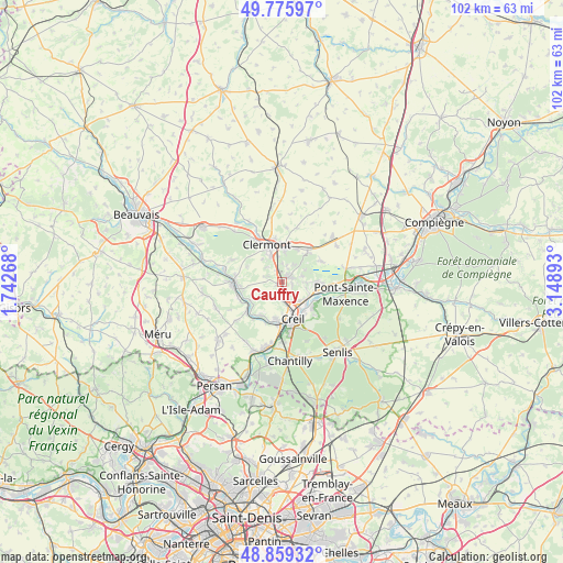
Cauffry GPS coordinates[2]
49° 19' 11.208" North, 2° 26' 44.916" East
| Map corner | latitude | longitude |
|---|---|---|
| Upper-left | 49.77597°, | 1.74268° |
| Center: | 49.31978°, | 2.44581° |
| Lower-right: | 48.85932°, | 3.14893° |
| Map W x H: | 101.9×101.9 km | = 63.3×63.3mi |
| max Lat: | 51.07786° ⇑13.5% North |
| Cauffry: | 49.31978° |
| min Lat: | ⇓86.5% South 41.3874° |
| min Long | Cauffry | max Long |
| -5.08615° | 2.44581° | 9.52242° |
| W 49.7%⇐ | ⇒50.3% E |
Elevation
Elevation of Cauffry is 47 m = 154 ft, and this is 146.7 m = 481 ft below average elevation for this country.
| Max E: |
2333 m = 7654 ft | 83.1% |
| Avg. | 193.7 m = 635 ft | |
| Cauffry | 47 m = 154 ft | |
Min E: |
-1 m = -3 ft | 16.9% |
See also: France elevation on elevation.city.
Geographical zone
Cauffry is located in North temperate zone (between Tropic of Cancer and the Arctic Circle). Distance of this North polar circle is 1917.3 km =1191.4 mi to North.| Distance of | km | miles | from Cauffry |
|---|---|---|---|
| North Pole | 4523.2 | 2810.6 | to North |
| Arctic Circle | 1917.3 | 1191.4 | to North |
| Tropic Cancer | 2877.9 | 1788.2 | to South |
| Equator | 5483.8 | 3407.5 | to South |


Nearby cities:
15 places around Cauffry: (largest is in red/bold)
• Angicourt
4.3 km =2.7 mi,  101°
101°
• Bailleval
3 km =1.9 mi,  15°
15°
• Breuil-le-Sec
5.7 km =3.5 mi,  3°
3°
• Breuil-le-Vert
4.7 km =2.9 mi,  351°
351°
• Cambronne-lès-Clermont
3.6 km =2.2 mi,  288°
288°
• Laigneville
3.1 km =1.9 mi,  180°
180°
• Liancourt
1.9 km =1.2 mi,  51°
51°
• Mogneville
1.9 km =1.2 mi, 104°
• Monchy-Saint-Éloi
3.6 km =2.2 mi,  154°
154°
• Neuilly-sous-Clermont
3.8 km =2.4 mi,  316°
316°
• Rantigny
0.9 km =0.6 mi,  344°
344°
• Rieux
5.6 km =3.5 mi,  113°
113°
• Rosoy
4.6 km =2.9 mi,  60°
60°
• Verderonne
4 km =2.5 mi,  73°
73°
• Villers-Saint-Paul
4.7 km =2.9 mi,  137°
137°
Sources, notices
• [Note1] Compared only with cities in France existing in our database
• [Src1] Map data: © OpenStreetMap contributors (CC-BY-SA)
• [Src2] Other city data from geonames.org with taken over terms of usage.
• [Src3] Geographical zone / Annual Mean Temperature by Robert A. Rohde @ Wikipedia
