Villers-Saint-Paul geodata
Villers-Saint-Paul (Hauts-de-France) is a populated place; located in France in Europe/Paris (GMT+2) time zone. With population of 6,216 people, there are 1592 cities with bigger population in this country. Compared to other cities in France, 85.8% of cities are located further ↓South; 50.4% of cities are located further ←West and 87.1% of cities have higher elevation than Villers-Saint-Paul. Note1
Administrative division(s):
- Level 1: Hauts-de-France
- Level 2: Département de l'Oise
- Level 3: Arrondissement de Senlis
- Level 4: Villers-Saint-Paul


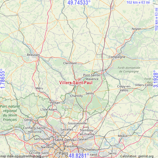
Villers-Saint-Paul GPS coordinates[2]
49° 17' 19.86" North, 2° 29' 22.848" East
| Map corner | latitude | longitude |
|---|---|---|
| Upper-left | 49.74533°, | 1.78655° |
| Center: | 49.28885°, | 2.48968° |
| Lower-right: | 48.8281°, | 3.1928° |
| Map W x H: | 102×102 km | = 63.4×63.4mi |
| max Lat: | 51.07786° ⇑14.2% North |
| Villers-Saint-Paul: | 49.28885° |
| min Lat: | ⇓85.8% South 41.3874° |
| min Long | Villers-Saint-P | max Long |
| -5.08615° | 2.48968° | 9.52242° |
| W 50.4%⇐ | ⇒49.6% E |
Elevation
Elevation of Villers-Saint-Paul is 37 m = 121 ft, and this is 156.7 m = 514 ft below average elevation for this country.
| Max E: |
2333 m = 7654 ft | 87.1% |
| Avg. | 193.7 m = 635 ft | |
| Villers-Saint-Paul | 37 m = 121 ft | |
Min E: |
-1 m = -3 ft | 12.9% |
See also: France elevation on elevation.city.
Geographical zone
Villers-Saint-Paul is located in North temperate zone (between Tropic of Cancer and the Arctic Circle). Distance of this North polar circle is 1920.8 km =1193.5 mi to North.| Distance of | km | miles | from Villers-Saint-Paul |
|---|---|---|---|
| North Pole | 4526.7 | 2812.8 | to North |
| Arctic Circle | 1920.8 | 1193.5 | to North |
| Tropic Cancer | 2874.5 | 1786.1 | to South |
| Equator | 5480.4 | 3405.4 | to South |


Nearby cities:
15 places around Villers-Saint-Paul: (largest is in red/bold)
• Angicourt
2.8 km =1.7 mi,  22°
22°
• Brenouille
4.4 km =2.7 mi,  64°
64°
• Cauffry
4.7 km =2.9 mi,  317°
317°
• Cinqueux
4.3 km =2.7 mi,  42°
42°
• Creil
3.6 km =2.2 mi,  185°
185°
• Laigneville
3.2 km =2 mi,  275°
275°
• Liancourt
4.9 km =3 mi,  339°
339°
• Mogneville
3.2 km =2 mi, 336°
• Monceaux
5.5 km =3.4 mi,  53°
53°
• Monchy-Saint-Éloi
1.6 km =1 mi, 276°
• Montataire
5 km =3.1 mi,  228°
228°
• Nogent-sur-Oise
2.4 km =1.5 mi,  215°
215°
• Rieux
2.3 km =1.4 mi, 57°
• Verderonne
4.6 km =2.9 mi,  7°
7°
• Verneuil-en-Halatte
2.7 km =1.7 mi,  113°
113°
Sources, notices
• [Note1] Compared only with cities in France existing in our database
• [Src1] Map data: © OpenStreetMap contributors (CC-BY-SA)
• [Src2] Other city data from geonames.org with taken over terms of usage.
• [Src3] Geographical zone / Annual Mean Temperature by Robert A. Rohde @ Wikipedia
