Calleville geodata
Calleville (Normandy) is a populated place; located in France in Europe/Paris (GMT+2) time zone. With population of 555 people, there are 14118 cities with bigger population in this country. Compared to other cities in France, 84.1% of cities are located further ↓South; 70.9% of cities are located further →East and 50.1% of cities have lower elevation than Calleville. Note1
Administrative division(s):
- Level 1: Normandy
- Level 2: Département de l'Eure
- Level 3: Arrondissement de Bernay
- Level 4: Calleville


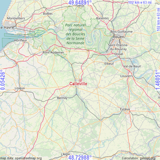
Calleville GPS coordinates[2]
49° 11' 29.508" North, 0° 45' 26.604" East
| Map corner | latitude | longitude |
|---|---|---|
| Upper-left | 49.64891°, | 0.05426° |
| Center: | 49.19153°, | 0.75739° |
| Lower-right: | 48.72988°, | 1.46051° |
| Map W x H: | 102.2×102.2 km | = 63.5×63.5mi |
| max Lat: | 51.07786° ⇑15.9% North |
| Calleville: | 49.19153° |
| min Lat: | ⇓84.1% South 41.3874° |
| min Long | Calleville | max Long |
| -5.08615° | 0.75739° | 9.52242° |
| W 29.1%⇐ | ⇒70.9% E |
Elevation
Elevation of Calleville is 132 m = 433 ft, and this is 61.7 m = 202 ft below average elevation for this country.
| Max E: |
2333 m = 7654 ft | 49.9% |
| Avg. | 193.7 m = 635 ft | |
| Calleville | 132 m = 433 ft | |
Min E: |
-1 m = -3 ft | 50.1% |
See also: France elevation on elevation.city.
Geographical zone
Calleville is located in North temperate zone (between Tropic of Cancer and the Arctic Circle). Distance of this North polar circle is 1931.6 km =1200.2 mi to North.| Distance of | km | miles | from Calleville |
|---|---|---|---|
| North Pole | 4537.5 | 2819.5 | to North |
| Arctic Circle | 1931.6 | 1200.2 | to North |
| Tropic Cancer | 2863.7 | 1779.4 | to South |
| Equator | 5469.6 | 3398.7 | to South |


Nearby cities:
15 places around Calleville: (largest is in red/bold)
• Beaumontel
12.1 km =7.5 mi,  178°
178°
• Berville-en-Roumois
12.6 km =7.8 mi,  22°
22°
• Boissey-le-Châtel
9.1 km =5.7 mi,  12°
12°
• Bosguérard-de-Marcouville
10.5 km =6.5 mi,  32°
32°
• Brionne
3.1 km =1.9 mi,  278°
278°
• Goupillières
7.2 km =4.5 mi, 177°
• Harcourt
3.4 km =2.1 mi,  143°
143°
• Le Gros-Theil
7.3 km =4.5 mi,  57°
57°
• Le Neubourg
12 km =7.5 mi,  112°
112°
• Nassandres
7.4 km =4.6 mi,  192°
192°
• Plasnes
11.5 km =7.1 mi,  237°
237°
• Pont-Authou
6.7 km =4.2 mi,  331°
331°
• Saint-Pierre-du-Bosguérard
12.1 km =7.5 mi,  48°
48°
• Serquigny
9.8 km =6.1 mi,  200°
200°
• Tourville-la-Campagne
11.3 km =7 mi,  69°
69°
Sources, notices
• [Note1] Compared only with cities in France existing in our database
• [Src1] Map data: © OpenStreetMap contributors (CC-BY-SA)
• [Src2] Other city data from geonames.org with taken over terms of usage.
• [Src3] Geographical zone / Annual Mean Temperature by Robert A. Rohde @ Wikipedia
