Byans-sur-Doubs geodata
Byans-sur-Doubs (Bourgogne-Franche-Comté) is a populated place; located in France in Europe/Paris (GMT+2) time zone. With population of 677 people, there are 12108 cities with bigger population in this country. Compared to other cities in France, 54.1% of cities are located further ↑North; 85.6% of cities are located further ←West and 80.6% of cities have lower elevation than Byans-sur-Doubs. Note1
Administrative division(s):
- Level 1: Bourgogne-Franche-Comté
- Level 2: Doubs
- Level 3: Arrondissement de Besançon
- Level 4: Byans-sur-Doubs


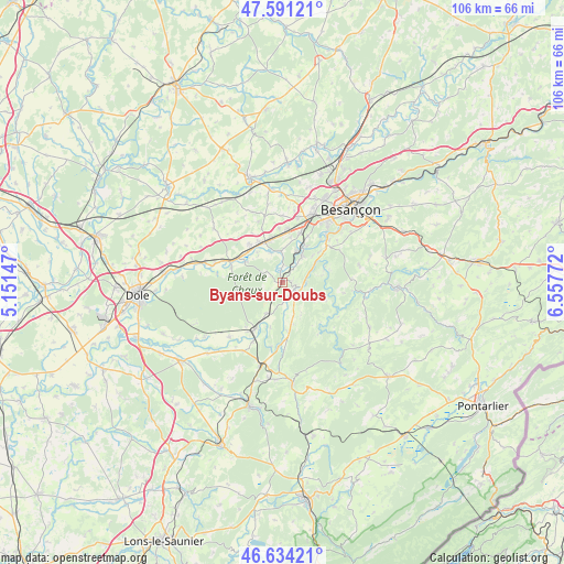
Byans-sur-Doubs GPS coordinates[2]
47° 6' 53.496" North, 5° 51' 16.56" East
| Map corner | latitude | longitude |
|---|---|---|
| Upper-left | 47.59121°, | 5.15147° |
| Center: | 47.11486°, | 5.8546° |
| Lower-right: | 46.63421°, | 6.55772° |
| Map W x H: | 106.4×106.4 km | = 66.1×66.1mi |
| max Lat: | 51.07786° ⇑54.1% North |
| Byans-sur-Doubs: | 47.11486° |
| min Lat: | ⇓45.9% South 41.3874° |
| min Long | Byans-sur-Doubs | max Long |
| -5.08615° | 5.8546° | 9.52242° |
| W 85.6%⇐ | ⇒14.4% E |
Elevation
Elevation of Byans-sur-Doubs is 297 m = 974 ft, and this is 103.3 m = 339 ft above average elevation for this country.
| Max E: |
2333 m = 7654 ft | 19.4% |
| Byans-sur-Doubs | 297 m 974 ft | |
| Avg. | 193.7 m = 635 ft | |
Min E: |
-1 m = -3 ft | 80.6% |
See also: France elevation on elevation.city.
Geographical zone
Byans-sur-Doubs is located in North temperate zone (between Tropic of Cancer and the Arctic Circle). Distance of this North polar circle is 2162.5 km =1343.7 mi to North.| Distance of | km | miles | from Byans-sur-Doubs |
|---|---|---|---|
| North Pole | 4768.4 | 2962.9 | to North |
| Arctic Circle | 2162.5 | 1343.7 | to North |
| Tropic Cancer | 2632.8 | 1635.9 | to South |
| Equator | 5238.7 | 3255.2 | to South |


Nearby cities:
15 places around Byans-sur-Doubs: (largest is in red/bold)
• Arc-et-Senans
11.3 km =7 mi,  214°
214°
• Boussières
6.1 km =3.8 mi,  37°
37°
• Busy
9.2 km =5.7 mi,  50°
50°
• Chenecey-Buillon
8.4 km =5.2 mi,  70°
70°
• Dampierre
9.6 km =6 mi,  297°
297°
• Dannemarie-sur-Crête
10.1 km =6.3 mi,  6°
6°
• Fraisans
8 km =5 mi, 297°
• Grandfontaine
9.8 km =6.1 mi,  20°
20°
• Liesle
6.6 km =4.1 mi, 207°
• Montferrand-le-Château
8.1 km =5 mi,  34°
34°
• Pouilley-Français
10.2 km =6.3 mi,  356°
356°
• Quingey
2.6 km =1.6 mi,  122°
122°
• Saint-Vit
8.1 km =5 mi,  339°
339°
• Torpes
6.4 km =4 mi, 23°
• Évans
9.7 km =6 mi,  317°
317°
Sources, notices
• [Note1] Compared only with cities in France existing in our database
• [Src1] Map data: © OpenStreetMap contributors (CC-BY-SA)
• [Src2] Other city data from geonames.org with taken over terms of usage.
• [Src3] Geographical zone / Annual Mean Temperature by Robert A. Rohde @ Wikipedia
