Chenecey-Buillon geodata
Chenecey-Buillon (Bourgogne-Franche-Comté) is a populated place; located in France in Europe/Paris (GMT+2) time zone. With population of 518 people, there are 14866 cities with bigger population in this country. Compared to other cities in France, 53.7% of cities are located further ↑North; 86.7% of cities are located further ←West and 79.3% of cities have lower elevation than Chenecey-Buillon. Note1
Administrative division(s):
- Level 1: Bourgogne-Franche-Comté
- Level 2: Doubs
- Level 3: Arrondissement de Besançon
- Level 4: Chenecey-Buillon


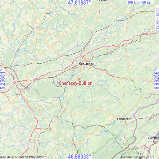
Chenecey-Buillon GPS coordinates[2]
47° 8' 26.7" North, 5° 57' 33.948" East
| Map corner | latitude | longitude |
|---|---|---|
| Upper-left | 47.61687°, | 5.25631° |
| Center: | 47.14075°, | 5.95943° |
| Lower-right: | 46.66033°, | 6.66256° |
| Map W x H: | 106.4×106.4 km | = 66.1×66.1mi |
| max Lat: | 51.07786° ⇑53.7% North |
| Chenecey-Buillon: | 47.14075° |
| min Lat: | ⇓46.3% South 41.3874° |
| min Long | Chenecey-Buillo | max Long |
| -5.08615° | 5.95943° | 9.52242° |
| W 86.7%⇐ | ⇒13.3% E |
Elevation
Elevation of Chenecey-Buillon is 283 m = 928 ft, and this is 89.3 m = 293 ft above average elevation for this country.
| Max E: |
2333 m = 7654 ft | 20.7% |
| Chenecey-Buillon | 283 m 928 ft | |
| Avg. | 193.7 m = 635 ft | |
Min E: |
-1 m = -3 ft | 79.3% |
See also: France elevation on elevation.city.
Geographical zone
Chenecey-Buillon is located in North temperate zone (between Tropic of Cancer and the Arctic Circle). Distance of this North polar circle is 2159.6 km =1341.9 mi to North.| Distance of | km | miles | from Chenecey-Buillon |
|---|---|---|---|
| North Pole | 4765.5 | 2961.1 | to North |
| Arctic Circle | 2159.6 | 1341.9 | to North |
| Tropic Cancer | 2635.6 | 1637.7 | to South |
| Equator | 5241.6 | 3257 | to South |


Nearby cities:
15 places around Chenecey-Buillon: (largest is in red/bold)
• Avanne-Aveney
6.6 km =4.1 mi,  4°
4°
• Beure
8.1 km =5 mi,  25°
25°
• Boussières
4.7 km =2.9 mi,  295°
295°
• Busy
3.1 km =1.9 mi,  343°
343°
• Byans-sur-Doubs
8.4 km =5.2 mi,  250°
250°
• Chemaudin
10.5 km =6.5 mi,  331°
331°
• Dannemarie-sur-Crête
9.8 km =6.1 mi,  316°
316°
• Fontain
8.2 km =5.1 mi,  37°
37°
• Franois
10.3 km =6.4 mi,  346°
346°
• Grandfontaine
7.7 km =4.8 mi, 324°
• Larnod
4.8 km =3 mi,  9°
9°
• Montferrand-le-Château
5.1 km =3.2 mi, 319°
• Pugey
5.4 km =3.4 mi, 25°
• Quingey
7.2 km =4.5 mi,  233°
233°
• Torpes
6.1 km =3.8 mi, 298°
Sources, notices
• [Note1] Compared only with cities in France existing in our database
• [Src1] Map data: © OpenStreetMap contributors (CC-BY-SA)
• [Src2] Other city data from geonames.org with taken over terms of usage.
• [Src3] Geographical zone / Annual Mean Temperature by Robert A. Rohde @ Wikipedia
