Bretteville-du-Grand-Caux geodata
Bretteville-du-Grand-Caux (Normandy) is a populated place; located in France in Europe/Paris (GMT+2) time zone. With population of 1,271 people, there are 7176 cities with bigger population in this country. Compared to other cities in France, 91.3% of cities are located further ↓South; 74.3% of cities are located further →East and 62% of cities have higher elevation than Bretteville-du-Grand-Caux. Note1
Administrative division(s):
- Level 1: Normandy
- Level 2: Seine-Maritime
- Level 3: Arrondissement du Havre
- Level 4: Bretteville-du-Grand-Caux
Current local time in Bretteville-du-Grand-Caux:
07:22 AM, SaturdayDifference from your time zone: hours


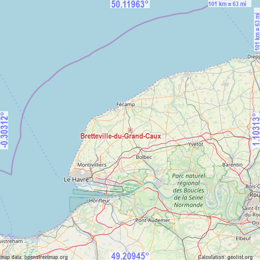
Bretteville-du-Grand-Caux GPS coordinates[2]
49° 40' 0.012" North, 0° 24' 0" East
| Map corner | latitude | longitude |
|---|---|---|
| Upper-left | 50.11963°, | -0.30312° |
| Center: | 49.66667°, | 0.4° |
| Lower-right: | 49.20945°, | 1.10313° |
| Map W x H: | 101.2×101.2 km | = 62.9×62.9mi |
| max Lat: | 51.07786° ⇑8.7% North |
| Bretteville-du-Grand-Caux: | 49.66667° |
| min Lat: | ⇓91.3% South 41.3874° |
| min Long | Bretteville-du- | max Long |
| -5.08615° | 0.4° | 9.52242° |
| W 25.7%⇐ | ⇒74.3% E |
Elevation
Elevation of Bretteville-du-Grand-Caux is 97 m = 318 ft, and this is 96.7 m = 317 ft below average elevation for this country.
| Max E: |
2333 m = 7654 ft | 62% |
| Avg. | 193.7 m = 635 ft | |
| Bretteville-du-Grand-Caux | 97 m = 318 ft | |
Min E: |
-1 m = -3 ft | 38% |
See also: France elevation on elevation.city.
Geographical zone
Bretteville-du-Grand-Caux is located in North temperate zone (between Tropic of Cancer and the Arctic Circle). Distance of this North polar circle is 1878.8 km =1167.4 mi to North.| Distance of | km | miles | from Bretteville-du-Grand-Caux |
|---|---|---|---|
| North Pole | 4484.6 | 2786.6 | to North |
| Arctic Circle | 1878.8 | 1167.4 | to North |
| Tropic Cancer | 2916.5 | 1812.2 | to South |
| Equator | 5522.4 | 3431.5 | to South |


Nearby cities:
15 places around Bretteville-du-Grand-Caux: (largest is in red/bold)
• Bec-de-Mortagne
5.2 km =3.2 mi,  42°
42°
• Bernières
7.5 km =4.7 mi,  131°
131°
• Beuzeville-la-Grenier
8.6 km =5.3 mi,  166°
166°
• Bréauté
4.3 km =2.7 mi,  179°
179°
• Froberville
7.8 km =4.8 mi,  322°
322°
• Goderville
3.4 km =2.1 mi,  226°
226°
• Les Loges
9.1 km =5.7 mi,  293°
293°
• Manneville-la-Goupil
7.1 km =4.4 mi,  207°
207°
• Rouville
9 km =5.6 mi, 127°
• Saint-Léonard
8.9 km =5.5 mi,  340°
340°
• Tourville-les-Ifs
5.2 km =3.2 mi,  0°
0°
• Toussaint
8.1 km =5 mi,  12°
12°
• Vattetot-sous-Beaumont
5.7 km =3.5 mi,  144°
144°
• Écrainville
5.7 km =3.5 mi,  250°
250°
• Épreville
5.1 km =3.2 mi,  330°
330°
Sources, notices
• [Note1] Compared only with cities in France existing in our database
• [Src1] Map data: © OpenStreetMap contributors (CC-BY-SA)
• [Src2] Other city data from geonames.org with taken over terms of usage.
• [Src3] Geographical zone / Annual Mean Temperature by Robert A. Rohde @ Wikipedia
