Brélès geodata
Brélès (Brittany) is a populated place; located in France in Europe/Paris (GMT+2) time zone. With population of 786 people, there are 10751 cities with bigger population in this country. Compared to other cities in France, 67.8% of cities are located further ↓South; 99.9% of cities are located further →East and 84.5% of cities have higher elevation than Brélès. Note1
Administrative division(s):
- Level 1: Brittany
- Level 2: Département du Finistère
- Level 3: Arrondissement de Brest
- Level 4: Brélès


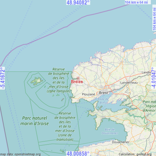
Brélès GPS coordinates[2]
48° 28' 36.624" North, 4° 42' 48.924" West
| Map corner | latitude | longitude |
|---|---|---|
| Upper-left | 48.94082°, | -5.41672° |
| Center: | 48.47684°, | -4.71359° |
| Lower-right: | 48.00858°, | -4.01047° |
| Map W x H: | 103.7×103.7 km | = 64.4×64.4mi |
| max Lat: | 51.07786° ⇑32.2% North |
| Brélès: | 48.47684° |
| min Lat: | ⇓67.8% South 41.3874° |
| min Long | Brélès | max Long |
| -5.08615° | -4.71359° | 9.52242° |
| W 0.1%⇐ | ⇒99.9% E |
Elevation
Elevation of Brélès is 43 m = 141 ft, and this is 150.7 m = 494 ft below average elevation for this country.
| Max E: |
2333 m = 7654 ft | 84.5% |
| Avg. | 193.7 m = 635 ft | |
| Brélès | 43 m = 141 ft | |
Min E: |
-1 m = -3 ft | 15.5% |
See also: France elevation on elevation.city.
Geographical zone
Brélès is located in North temperate zone (between Tropic of Cancer and the Arctic Circle). Distance of this North polar circle is 2011.1 km =1249.6 mi to North.| Distance of | km | miles | from Brélès |
|---|---|---|---|
| North Pole | 4616.9 | 2868.8 | to North |
| Arctic Circle | 2011.1 | 1249.6 | to North |
| Tropic Cancer | 2784.2 | 1730 | to South |
| Equator | 5390.1 | 3349.3 | to South |


Nearby cities:
15 places around Brélès: (largest is in red/bold)
• Guipronvel
10.4 km =6.5 mi,  81°
81°
• Lampaul-Plouarzel
4.8 km =3 mi,  226°
226°
• Lampaul-Ploudalmézeau
10.3 km =6.4 mi,  24°
24°
• Landunvez
6.5 km =4 mi,  352°
352°
• Lanildut
2.8 km =1.7 mi,  285°
285°
• Lanrivoaré
5.5 km =3.4 mi,  94°
94°
• Milizac
10.9 km =6.8 mi,  95°
95°
• Plouarzel
5.1 km =3.2 mi,  196°
196°
• Ploudalmézeau
7.8 km =4.8 mi,  36°
36°
• Plouguin
10.5 km =6.5 mi,  53°
53°
• Ploumoguer
8.5 km =5.3 mi,  181°
181°
• Plouzané
12.6 km =7.8 mi,  145°
145°
• Porspoder
4.7 km =2.9 mi,  303°
303°
• Rd pt des Chataigniers, Rte de Milizac, Guilers, Finistère, France
11.7 km =7.3 mi,  114°
114°
• Saint-Renan
8.6 km =5.3 mi,  124°
124°
Sources, notices
• [Note1] Compared only with cities in France existing in our database
• [Src1] Map data: © OpenStreetMap contributors (CC-BY-SA)
• [Src2] Other city data from geonames.org with taken over terms of usage.
• [Src3] Geographical zone / Annual Mean Temperature by Robert A. Rohde @ Wikipedia
