Ploudalmézeau geodata
Ploudalmézeau (Brittany) is a populated place; located in France in Europe/Paris (GMT+2) time zone. With population of 5,243 people, there are 1877 cities with bigger population in this country. Compared to other cities in France, 69.1% of cities are located further ↓South; 99.9% of cities are located further →East and 76.6% of cities have higher elevation than Ploudalmézeau. Note1
Administrative division(s):
- Level 1: Brittany
- Level 2: Département du Finistère
- Level 3: Arrondissement de Brest
- Level 4: Ploudalmézeau


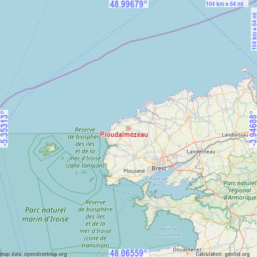
Ploudalmézeau GPS coordinates[2]
48° 31' 59.988" North, 4° 39' 0" West
| Map corner | latitude | longitude |
|---|---|---|
| Upper-left | 48.99679°, | -5.35313° |
| Center: | 48.53333°, | -4.65° |
| Lower-right: | 48.06559°, | -3.94688° |
| Map W x H: | 103.5×103.5 km | = 64.3×64.3mi |
| max Lat: | 51.07786° ⇑30.9% North |
| Ploudalmézeau: | 48.53333° |
| min Lat: | ⇓69.1% South 41.3874° |
| min Long | Ploudalmézeau | max Long |
| -5.08615° | -4.65° | 9.52242° |
| W 0.1%⇐ | ⇒99.9% E |
Elevation
Elevation of Ploudalmézeau is 63 m = 207 ft, and this is 130.7 m = 429 ft below average elevation for this country.
| Max E: |
2333 m = 7654 ft | 76.6% |
| Avg. | 193.7 m = 635 ft | |
| Ploudalmézeau | 63 m = 207 ft | |
Min E: |
-1 m = -3 ft | 23.4% |
See also: France elevation on elevation.city.
Geographical zone
Ploudalmézeau is located in North temperate zone (between Tropic of Cancer and the Arctic Circle). Distance of this North polar circle is 2004.8 km =1245.7 mi to North.| Distance of | km | miles | from Ploudalmézeau |
|---|---|---|---|
| North Pole | 4610.7 | 2865 | to North |
| Arctic Circle | 2004.8 | 1245.7 | to North |
| Tropic Cancer | 2790.5 | 1733.9 | to South |
| Equator | 5396.4 | 3353.2 | to South |


Nearby cities:
15 places around Ploudalmézeau: (largest is in red/bold)
• Bourg-Blanc
11.4 km =7.1 mi,  109°
109°
• Brélès
7.8 km =4.8 mi,  216°
216°
• Coat-Méal
8.5 km =5.3 mi, 108°
• Guipronvel
7.3 km =4.5 mi,  130°
130°
• Lampaul-Ploudalmézeau
3.1 km =1.9 mi,  353°
353°
• Landunvez
5.6 km =3.5 mi,  271°
271°
• Landéda
8.4 km =5.2 mi,  44°
44°
• Lanildut
9.2 km =5.7 mi,  232°
232°
• Lannilis
10.3 km =6.4 mi,  66°
66°
• Lanrivoaré
6.7 km =4.2 mi,  172°
172°
• Milizac
9.6 km =6 mi,  140°
140°
• Plouguin
3.7 km =2.3 mi,  90°
90°
• Porspoder
9.4 km =5.8 mi,  246°
246°
• Saint-Pabu
5.2 km =3.2 mi, 44°
• Tréglonou
8.8 km =5.5 mi,  77°
77°
Sources, notices
• [Note1] Compared only with cities in France existing in our database
• [Src1] Map data: © OpenStreetMap contributors (CC-BY-SA)
• [Src2] Other city data from geonames.org with taken over terms of usage.
• [Src3] Geographical zone / Annual Mean Temperature by Robert A. Rohde @ Wikipedia
