Bourgneuf geodata
Bourgneuf (Nouvelle-Aquitaine) is a populated place; located in France in Europe/Paris (GMT+2) time zone. With population of 1,120 people, there are 8013 cities with bigger population in this country. Compared to other cities in France, 64% of cities are located further ↑North; 88.3% of cities are located further →East and 85.9% of cities have higher elevation than Bourgneuf. Note1
Administrative division(s):
- Level 1: Nouvelle-Aquitaine
- Level 2: Charente-Maritime
- Level 3: Arrondissement de La Rochelle
- Level 4: Bourgneuf


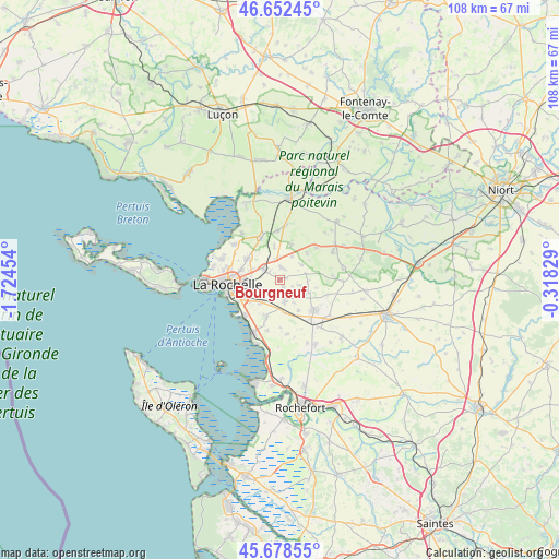
Bourgneuf GPS coordinates[2]
46° 10' 3.576" North, 1° 1' 17.076" West
| Map corner | latitude | longitude |
|---|---|---|
| Upper-left | 46.65245°, | -1.72454° |
| Center: | 46.16766°, | -1.02141° |
| Lower-right: | 45.67855°, | -0.31829° |
| Map W x H: | 108.3×108.3 km | = 67.3×67.3mi |
| max Lat: | 51.07786° ⇑64% North |
| Bourgneuf: | 46.16766° |
| min Lat: | ⇓36% South 41.3874° |
| min Long | Bourgneuf | max Long |
| -5.08615° | -1.02141° | 9.52242° |
| W 11.7%⇐ | ⇒88.3% E |
Elevation
Elevation of Bourgneuf is 40 m = 131 ft, and this is 153.7 m = 504 ft below average elevation for this country.
| Max E: |
2333 m = 7654 ft | 85.9% |
| Avg. | 193.7 m = 635 ft | |
| Bourgneuf | 40 m = 131 ft | |
Min E: |
-1 m = -3 ft | 14.1% |
See also: France elevation on elevation.city.
Geographical zone
Bourgneuf is located in North temperate zone (between Tropic of Cancer and the Arctic Circle). Distance of this North polar circle is 2267.8 km =1409.1 mi to North.| Distance of | km | miles | from Bourgneuf |
|---|---|---|---|
| North Pole | 4873.7 | 3028.4 | to North |
| Arctic Circle | 2267.8 | 1409.1 | to North |
| Tropic Cancer | 2527.4 | 1570.5 | to South |
| Equator | 5133.4 | 3189.7 | to South |


Nearby cities:
15 places around Bourgneuf: (largest is in red/bold)
• Clavette
3.1 km =1.9 mi,  189°
189°
• Croix-Chapeau
6.4 km =4 mi,  172°
172°
• Dompierre-sur-Mer
4 km =2.5 mi,  305°
305°
• La Jarne
5.9 km =3.7 mi,  221°
221°
• La Jarrie
4.4 km =2.7 mi, 167°
• Longèves
7.3 km =4.5 mi,  18°
18°
• Montroy
1.6 km =1 mi,  149°
149°
• Puilboreau
7.7 km =4.8 mi,  285°
285°
• Périgny
6.1 km =3.8 mi,  256°
256°
• Saint-Christophe
6.2 km =3.9 mi,  113°
113°
• Saint-Rogatien
4.2 km =2.6 mi,  242°
242°
• Saint-Xandre
7.5 km =4.7 mi,  303°
303°
• Sainte-Soulle
2.4 km =1.5 mi,  10°
10°
• Salles-sur-Mer
7.5 km =4.7 mi,  201°
201°
• Vérines
5.1 km =3.2 mi,  55°
55°
Sources, notices
• [Note1] Compared only with cities in France existing in our database
• [Src1] Map data: © OpenStreetMap contributors (CC-BY-SA)
• [Src2] Other city data from geonames.org with taken over terms of usage.
• [Src3] Geographical zone / Annual Mean Temperature by Robert A. Rohde @ Wikipedia
