Puilboreau geodata
Puilboreau (Nouvelle-Aquitaine) is a populated place; located in France in Europe/Paris (GMT+2) time zone. With population of 4,887 people, there are 2027 cities with bigger population in this country. Compared to other cities in France, 63.8% of cities are located further ↑North; 89.3% of cities are located further →East and 92.4% of cities have higher elevation than Puilboreau. Note1
Administrative division(s):
- Level 1: Nouvelle-Aquitaine
- Level 2: Charente-Maritime
- Level 3: Arrondissement de La Rochelle
- Level 4: Puilboreau


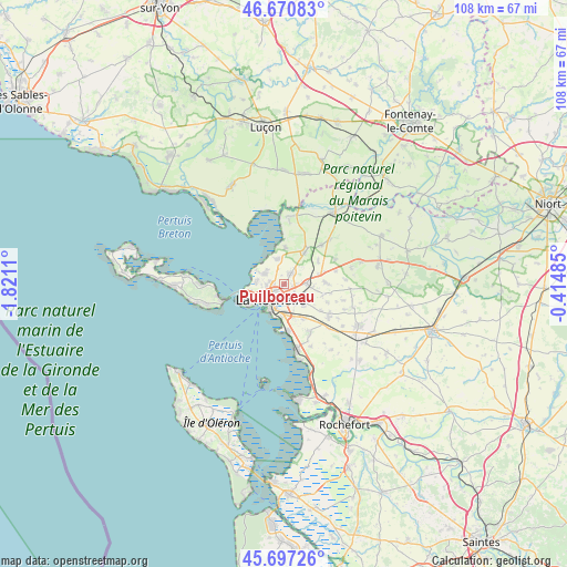
Puilboreau GPS coordinates[2]
46° 11' 10.32" North, 1° 7' 4.692" West
| Map corner | latitude | longitude |
|---|---|---|
| Upper-left | 46.67083°, | -1.8211° |
| Center: | 46.1862°, | -1.11797° |
| Lower-right: | 45.69726°, | -0.41485° |
| Map W x H: | 108.3×108.2 km | = 67.3×67.2mi |
| max Lat: | 51.07786° ⇑63.8% North |
| Puilboreau: | 46.1862° |
| min Lat: | ⇓36.2% South 41.3874° |
| min Long | Puilboreau | max Long |
| -5.08615° | -1.11797° | 9.52242° |
| W 10.7%⇐ | ⇒89.3% E |
Elevation
Elevation of Puilboreau is 24 m = 79 ft, and this is 169.7 m = 557 ft below average elevation for this country.
| Max E: |
2333 m = 7654 ft | 92.4% |
| Avg. | 193.7 m = 635 ft | |
| Puilboreau | 24 m = 79 ft | |
Min E: |
-1 m = -3 ft | 7.6% |
See also: France elevation on elevation.city.
Geographical zone
Puilboreau is located in North temperate zone (between Tropic of Cancer and the Arctic Circle). Distance of this North polar circle is 2265.8 km =1407.9 mi to North.| Distance of | km | miles | from Puilboreau |
|---|---|---|---|
| North Pole | 4871.6 | 3027.1 | to North |
| Arctic Circle | 2265.8 | 1407.9 | to North |
| Tropic Cancer | 2529.5 | 1571.8 | to South |
| Equator | 5135.4 | 3191 | to South |


Nearby cities:
15 places around Puilboreau: (largest is in red/bold)
• Aytré
5.6 km =3.5 mi,  177°
177°
• Bourgneuf
7.7 km =4.8 mi,  105°
105°
• Clavette
8.6 km =5.3 mi,  126°
126°
• Dompierre-sur-Mer
4.2 km =2.6 mi,  87°
87°
• Esnandes
7.1 km =4.4 mi,  1°
1°
• La Jarne
7.4 km =4.6 mi,  151°
151°
• La Rochelle
3.3 km =2.1 mi,  228°
228°
• Lagord
2.7 km =1.7 mi,  274°
274°
• Marsilly
5.1 km =3.2 mi,  342°
342°
• Nieul-sur-Mer
4.2 km =2.6 mi,  301°
301°
• Périgny
3.8 km =2.4 mi,  156°
156°
• Saint-Rogatien
5.5 km =3.4 mi,  137°
137°
• Saint-Xandre
2.3 km =1.4 mi,  30°
30°
• Sainte-Soulle
7.8 km =4.8 mi, 88°
• Villedoux
7.2 km =4.5 mi, 32°
Sources, notices
• [Note1] Compared only with cities in France existing in our database
• [Src1] Map data: © OpenStreetMap contributors (CC-BY-SA)
• [Src2] Other city data from geonames.org with taken over terms of usage.
• [Src3] Geographical zone / Annual Mean Temperature by Robert A. Rohde @ Wikipedia
